Earliest source: William L. Payson. "Notes on Some Tory Row Land Titles." The Proceedings of the Cambridge Historical Society vol. 37. 29 January 1957.toryrow
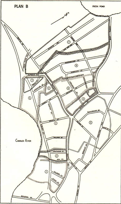
This map is actually from 1957 (I think), but it documents the Tory Row estates in the pre-Revolutionary War period. The area marked as number 3 (both sides of brattle with the lighter broken-line boundaries) is the estate of John Vassal. The observatory grounds are all the way to the right above Bond St. (the rightmost street with a label on it). According to this source, which admits to not being entirely thorough, the Vassal estate covered one corner of the Summer-house hill, eventually the obseratory. I think the line here would include the summit, where the Summer House stood, but it's not entirely clear.
Note that the streets are as they existed in 1957, not 1775. I don't think Bond Street existed at all until the Observatory was built, and if it did, would have had a different name. Likewise, Craigie Street wouldn't have had that name.
Vasall was loyal to the crown, and chose the wrong side when the Revolutionary War started. He fled and the Commonwealth seized the property. George Washington used his home as his headquarters for a year in 1775-76. The Commonwealth eventually sold the estate, and after changing hands a couple of times, it was sold to pharmacist and investor, Andrew Craigie. Craigie was both unwise and corrupt in his investments, and by the end of his life wouldn't leave his home for fear of arrest. He died of a stroke in 1819. His wife Elizabeth rented out rooms to cover his debt, until her death in 1841. Harvard purchased the Obsevatory grounds just a few months later from Craigie's heirs, grandchildren of his sisters (both from the same husband, Bossenger Foster (serially)).
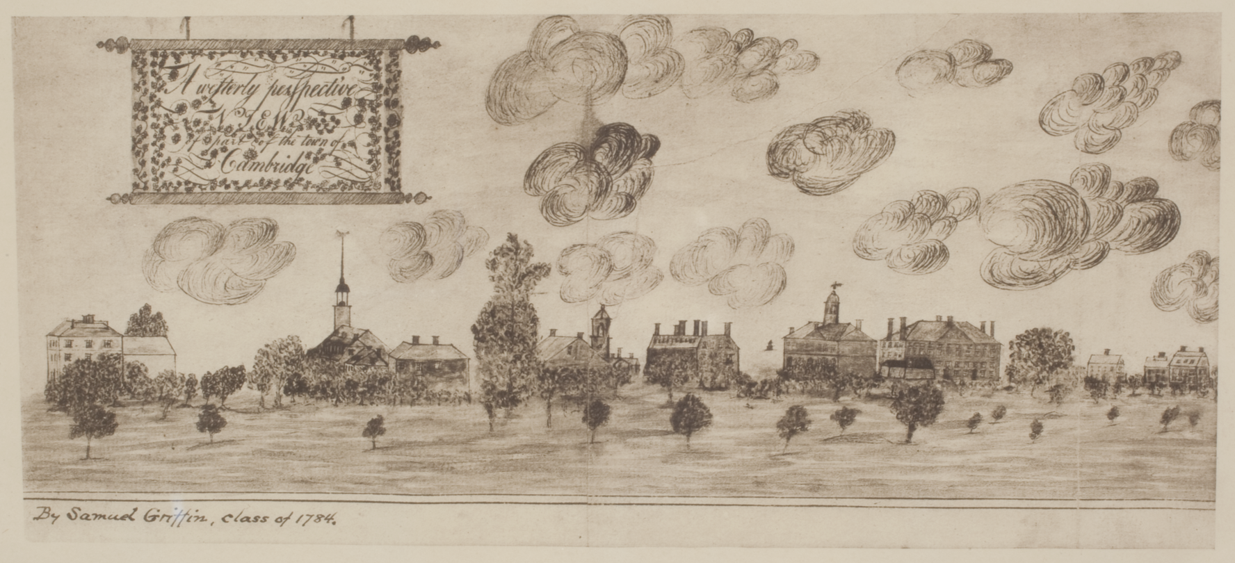
A Sketch from 1784 of Harvard, facing West. Just to the right of the center of the image is Massachusetts Hall, to its right in the distance (before the next adjacent building which is Harvard Hall), is a small structure on a hill. This is Summerhouse Hill, future site of the Observatory.
Samuel Griffin may have included this drawing as part of his mathematical thesis. It was displayed at an exhibition in April 1784.
Griffin later moved to Virginia, where he was killed by one of his wife's slaves in 1812.
At this point, Summerhouse Hill was part of the John Vassal estate. Vassal's home is now a national park site, the Longfellow House on Brattle Street. Vassal abandoned his property when the Revolutionary War broke out, because he was loyal to the King.
(Most of the information here comes from the Harvard Library Bulletin Volume 1 Number 3, Views of Harvard to 1860, Part III).
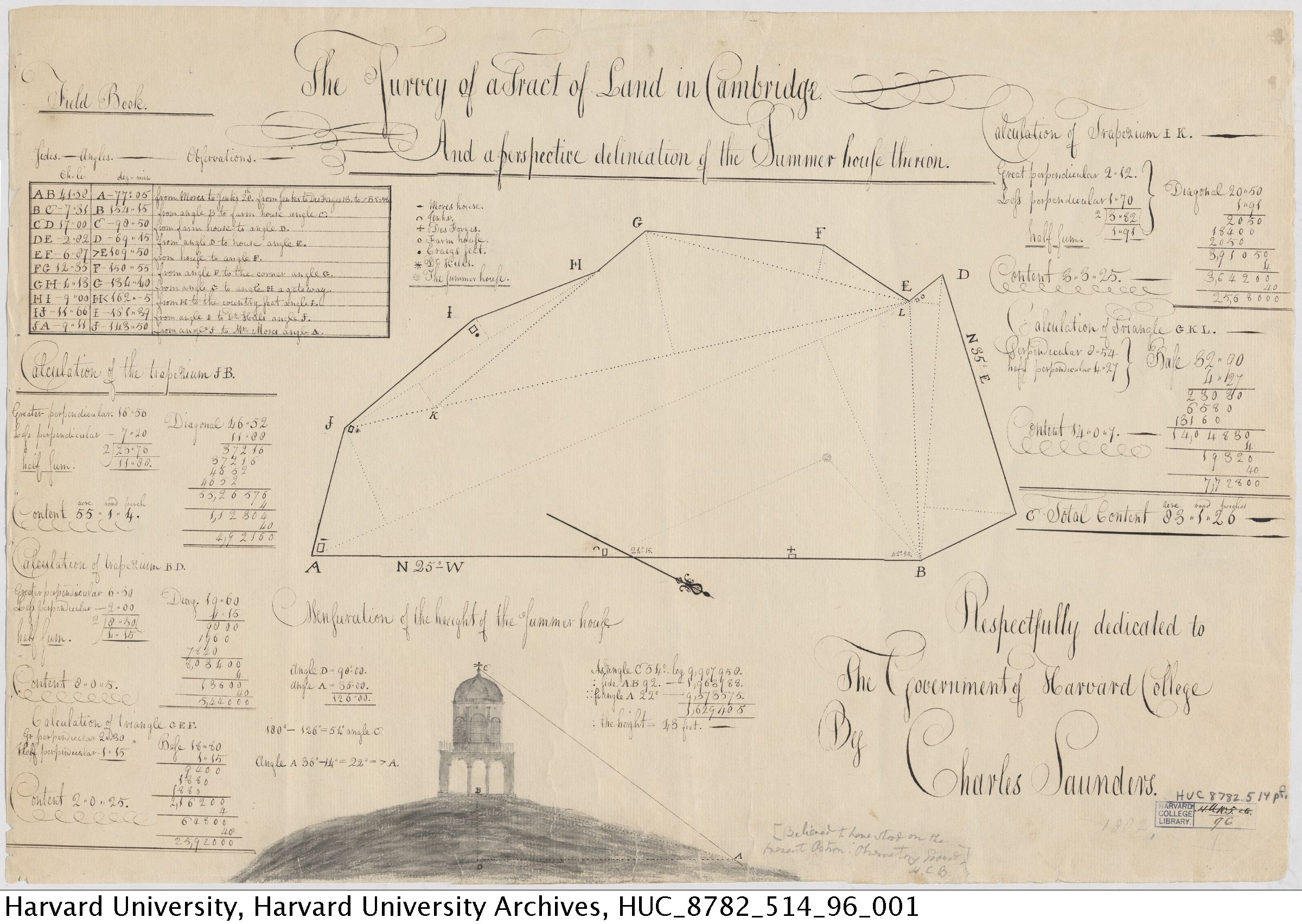
Summerhouse hill, before it was Observatory Hill and before the Observatory existed at all. At this point it was owned by Andrew Craigie who's heirs would eventually sell it to the observatory.
Andrew Craigie, in addition to being a corrupt politician, was also a great innovator. He was one of the earliest people to build a greenhouse, even though it was considered unnatural by many at the time. He was also an early adopter of the concept of an ice-house. And it was built underneath his summerhouse, where early excavations for the Observatory would find signs of its existence.
From Charles Saunders' mathematical thesis.
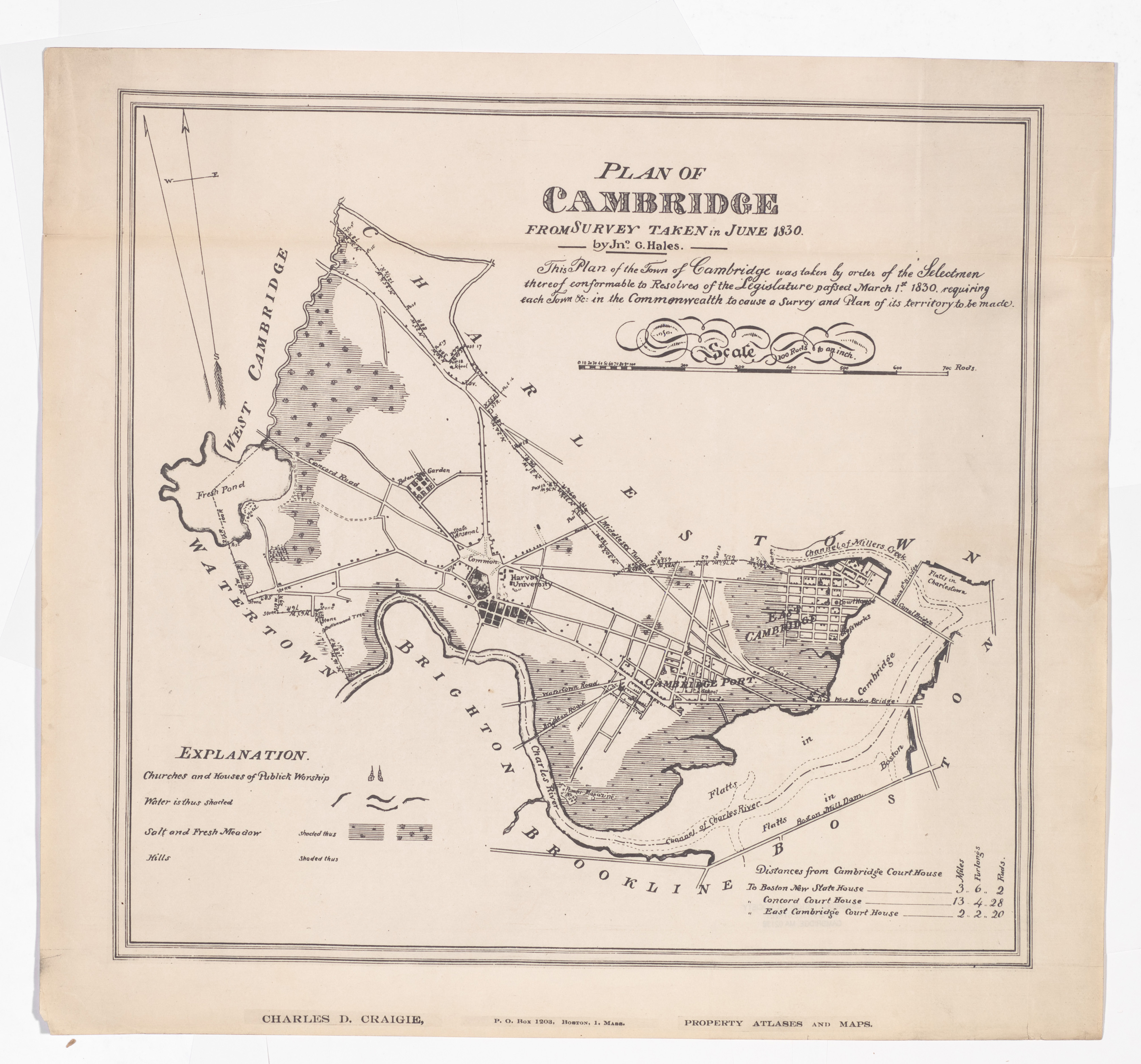
An 1830 map of Cambridge. The area the observatory will occupy is across the street from the Botanical Garden (for which Garden Street was named) and to the south. None of the cross streets from Graden to Concord are show except for what is now Huron. I'm assuming they were not actually there at the time. The structure on Summerhouse Hill would be in this area, but is not shown.
It's possible the summer house was already gone at this point. When the Observatory was built in 1844, it was apparently a surprise discovery that they were building on the old foundation of the summer house (on the ice-storage basement).
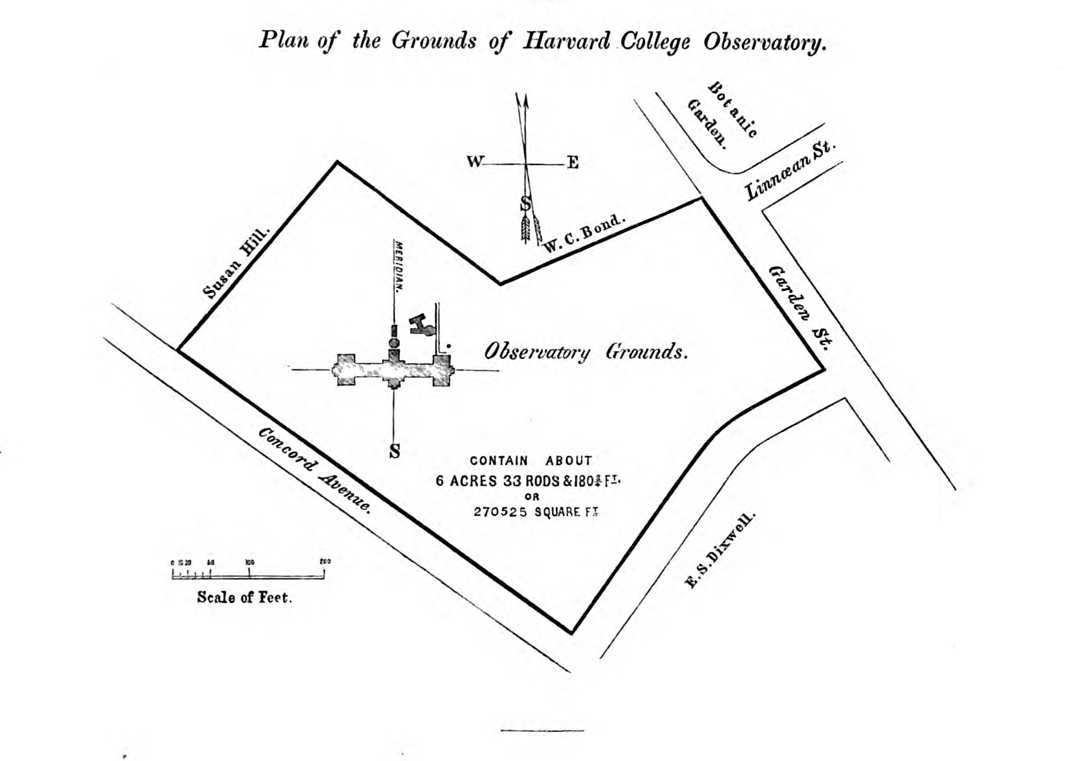
Earliest source: William Cranch Bond. Annals of the Astronomical Observatory of Harvard College / History and Description of the Astronomical Observatory of Harvard College vol. 1. Metcalf and Company, 1856.annals1
Earliest plan (found so far) of the observatory property, one year after the buildings were (mostly) completed. Other sources date this diagram to 1845
Still several areas for further research here.
When was Bond Street to the south named? Perhaps already, as it was likely done as a memorial to the son who died in 1841, rather than the director.
Was Madison Street (to the northeast, where it says "Susan Hill") already there? Other maps are unclear, the lack of a street doesn't mean it wasn't there, and one map I've seen has two parallel streets there before Huron (which was then Wyeth).
Was this before or after a land purchase from Susan Hill? Did they buy only part?
What was the old property line between Craigie/Foster heirs, and the other seller (Hill?)?
Where's the rest of the acreage? In the attached notes, it says that the university purchased 484,605 square feet from the Foster heirs (Craigie's sisters' descendants). But the drawn property is only 270,525 square feet. Also, it says that 62,271 square feet were purchased from Miss Hill. And elsewhere Harvard records indicate that part of the land they bought was then resold, for $600 (out of a total land purchase cost of $8288.85 according to this Annals).
When did the University buy additional property lablelled here as "W.C. Bond" (and was that the father or son?). A portion here was later purchased by Harvard from Selina Bond, the director's daughter, to expand the Observatory grounds to the modern borders.
Earliest source: William Cranch Bond. "Description of the Observatory at Cambridge." Memoirs of the American Academy of Arts and Sciences vol. 4. Metcalf and Company, 1849.academybond
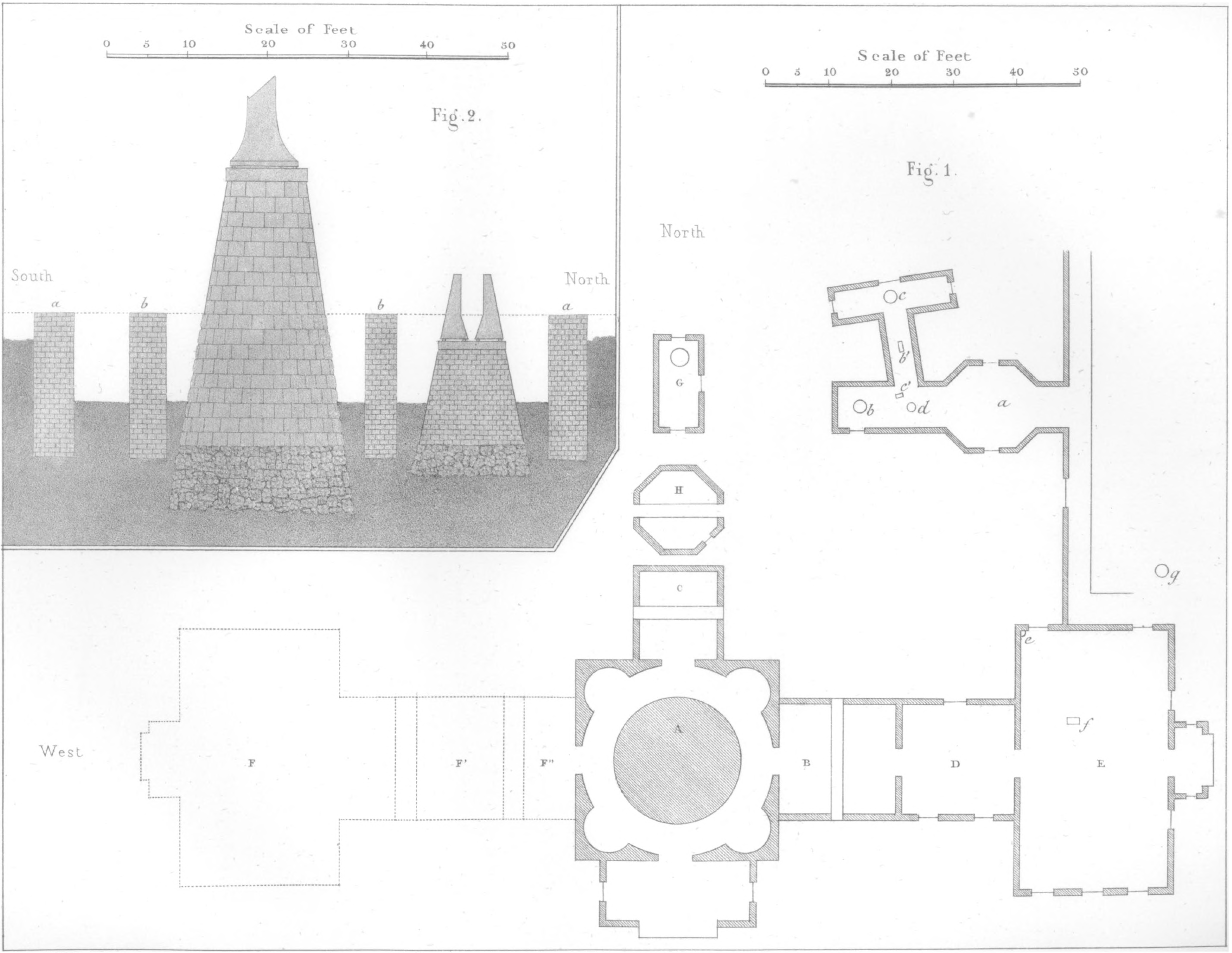
Earliest found plan of the observatory so far. Here are the descriptions found in this book:
Plate I., Fig. 1, is a ground plan of the principal buidings and of those appropriated to magnetc and meteorological purposes; at
A is the equatorial room and pier.
B, The transit-circle room.
C, The prime-vertical apartment.
In the smaller buildings,
a. The situation of the four-foot meridian-transit instrument.
b, The horizontal-force magnetometer.
c. The declination magnetometer.
b' and c', The reading telescopes of the magnetometers.
d, The small altitude and azimuth instrument.
In the construction of the buildings which protect the magnetic instruments, iron has been entirely excluded.
The wires connecting with a system of magnetic-telegraph lines, extending to most of the principal cities of the United States, are brought into the building containing the four-foot transit instrument, at a.
e is the situation of the standard barometer, made by Newman.
f, The transit or sidereal clock.
g, The deep well, for temperature of the earth at different depths below the surface.
G is a building used for miscellaneous purposes, chiefly for observation of the magnetic inclination; no iron was used in its construction.
H, The smaller prime-vertical room.
D, The computing room.
E, The observer's dwelling-house.
The western wing, indicated by dotted lines at F, F', F'', is not yet built.
Plate I., Fig. 2, is a north and south section of the foundations of the walls of the equatorial and prime-vertical rooms, and of their respective piers; at a a are the foundatons of the outer walls, and at b b those of the inner walls; the latter support the dome.
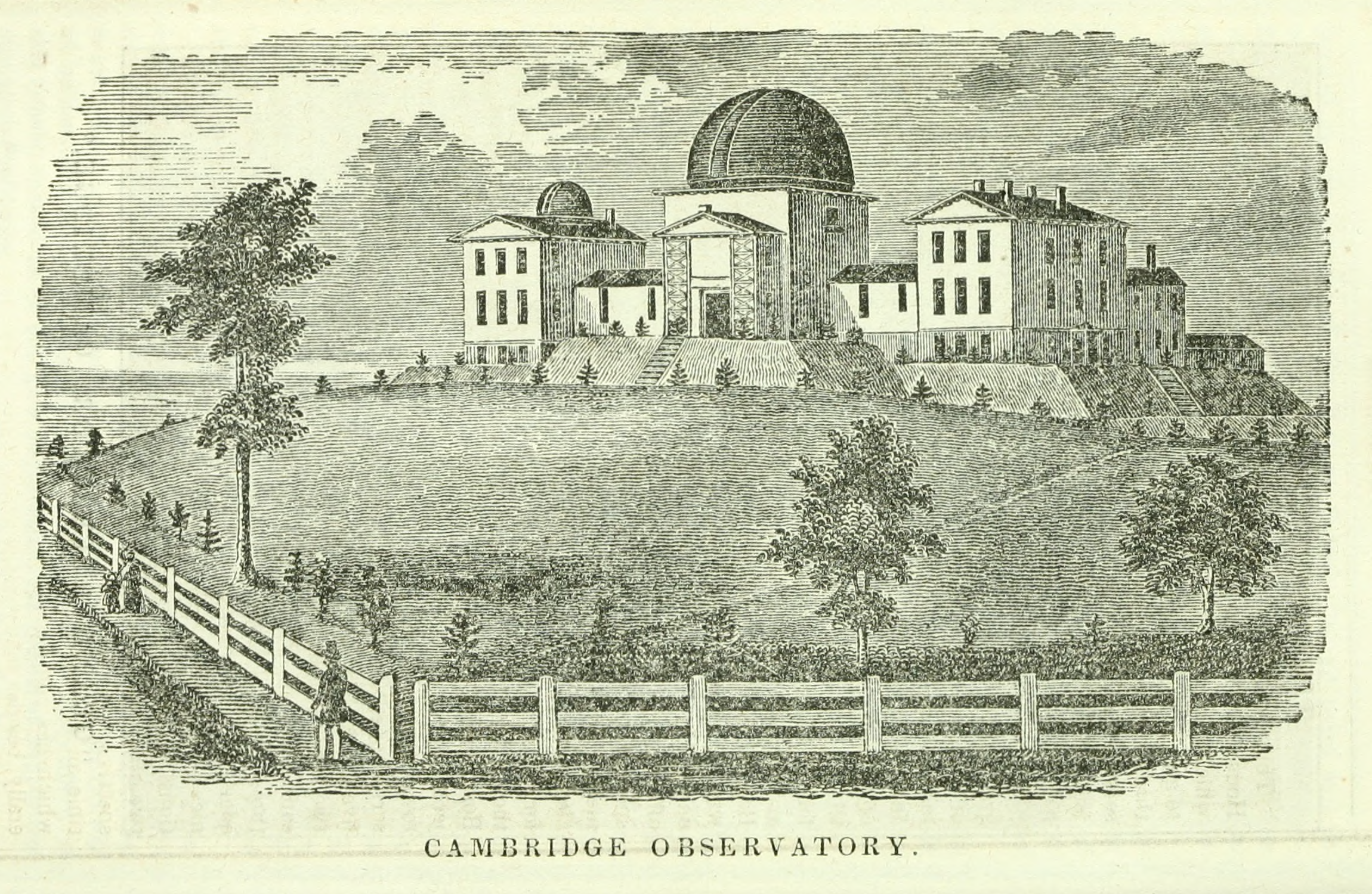
Earliest source: Isaac Smith Homans. Sketches of Boston, past and present / and of some few places in its vicinity. Phillips, Sampson, and Company, 1851.sketches
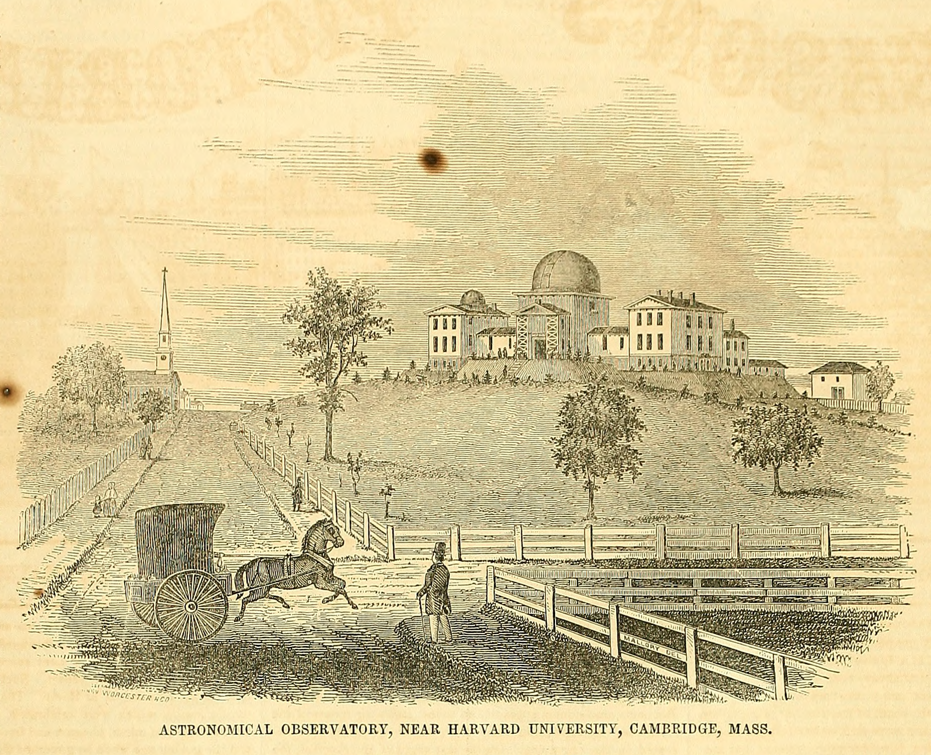
Image Credit: Richard P. Mallory; Worcester and Co.
Earliest source: Gleason's Pictorial Drawing Room Companion. 1851.gleason
This is one of two nearly identical woodcuts showing this view, from the corner of Concord Ave and Bond St. This version has been reproduced into the modern era, with a colorized version appearing on some Harvard Observatory websites currently. The other version from Sears' book is below.
This view includes the St. Peter's Church on the left, which is still there today, and was completed in 1848, and dedicated in May 1849. This was about one year after the Observatory installed the Great Refractor.
According to the Harvard Library Bulletin (Volume III, beginning around pg. 58), there are two slightly different versions of this image, due to a reprint of the early issues in 1853 to fill demand. This is apparently from the reprint. I've seen copies that are the original, and can't see any difference between the versions, but unfortunately I haven't found any good copies, just monochromatic pixelated versions.
The Libary also suggests that all of these are based on a drawing they had acquired recently (as of 1949 I think) but I can't currently find any such drawing in their collection.
Image credit company name is found in lower left corner. The artists name appears on fencework in the foreground ("Mallory del").
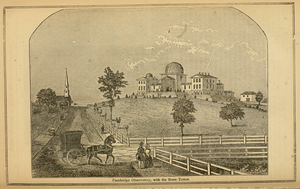
Image Credit: S.F. Baker SC.
Earliest source: Robert Sears. A Pictorial Description of the United States. 1852.pictorialus
This is one of two nearly identical woodcuts showing this view, from the corner of Concord Ave and Bond St. The other is above, from Gleason's Pictorial Drawing Room Companion, volume I.
According to the Harvard Library Bulletin (Volume III, beginning around pg. 58), this image appears in the the 1852 edition, though I haven't personally seen that. The closest I've seen is the torn edge of this missing page (pg. 71) in online scans of the 1854 edition. The Bulletin suggests that the "Sketches of Boston" woodcut may have used the same, reworked blocks. Given that the view is reduced in that image, and the clouds are different, I think one of the two views that shows both Concord and Bond Avenues must be the original.
Image credit is found in lower left corner.
Image Credit: H. F. Walling
Map of Cambridge from 1854. A rough outline of the observatory is shown on the grounds, along with a drive which used to connect Garden Street to Concord Avenue. Bond Street is not labelled with a name. Farther up Garden Street, we can see a home labelled "G. P. Bond". This would be George Phillip Bond, future director and one of the son of the director at that time, William Cranch Bond (who would have been living in the residence on Observatory property).
I've seen indications elsewhere that Bond St. was named in 1842, which seems off. However one of the director's sons, William Cranch Jr., died in 1842, and it may be that the street was named after him.
It doesn't show the borders of the Observatory property, but Harvard did not own all the way to Huron Ave (called Vassal Lane on this map). The southwest part of the property extended to what we now call Madison Street (not shown, but I've seen it in an 1852 map), but the northwest did not. The Observatory later purchased part of the northwest corner from Selina Bond (which seems suspicious to me, but I haven't looked into it yet).

Earliest source: "[Observatory buildings]." Harvard University Archives / UAV 630.271 (205). Harvard Libraries, olvwork431857
Harvard says this is ca. 1910-1930. Harvard is so very wrong. The latest this can possibly be is about 1875 when they added alcoves onto the west wing, which are not apparent here.
I actually think this is from before my other earliest photo, the one from 1865. In that photo there is a fence line which I am guessing is Buckingham Street. It doesn't seem to exist here. This would make this the middle of the property labelled as "Prof. Guyot" in the 1854 map above. It also appears that some of the landscaping described in 1853 is in place here, although I can't be sure. Based on these, I sort of arbitrarily picked 1855 as a reasonable guess, but anything as early as 1850 or 1851 (when the west wing was completed) is possible.
Buckingham street was laid out in 1855cambuildings, and by 1861 appeared on maps. It's possible that the whitish streak on the left edge of the image is the beginnings of this street. Even the foreground white streak could be part of Buckingham, as it is a dogleg.
St. Peters' Parish church would be just off of the left edge of the picture. I initially conisdered the possibility that it didn't exist yet, but it was completed in 1848, and the west wing of the Observatory (the left side) wasn't completed as of 1849.academybond On the other hand, there was apparently a house built on Concord next to the church in 1859, on the nearside.cambuildings It should be visible but is not here, so I'm setting 1859 as the upper limit for this image.
Identifying the photographic process might also help here. Daguerreotypes were the mainstay for photography in the 1840s and 50s, but this is obviously not a daguerreotype. Paper-based photography was very new around this time period. This could be a calotype, which directly exposed the image on paper and was available when the Observatory was built; however its use was rare in the United States. More likely it's an albumen print, which printed on paper from glass negatives, and would probably date this photo as sometime after 1850.
WARNING: this last part is unsubstantiated wild speculation:
Photographer John Whipple independently developed his own albumen process in the mid-to-late 1840s. Whipple was a famous Boston photographer, who was associated with the Observatory around this time. He is known for taking several award-winning daguerreotypes of the moon through a telescope around 1850-1852, as well as the first photograph of a star through a telescope, which was taken using Harvard's Great Refractor with the cooperation of Bond. This photo could be an early experiment of his with various paper-based technologies.
(end wild speculation)

Earliest source: William Cranch Bond. Annals of the Astronomical Observatory of Harvard College / History and Description of the Astronomical Observatory of Harvard College vol. 1. Metcalf and Company, 1856.annals1
Similar diagram to the 1848 verson, with different labels.

Image Credit: unknown
Earliest source: William Cranch Bond. Annals of the Astronomical Observatory of Harvard College / History and Description of the Astronomical Observatory of Harvard College vol. 1. Metcalf and Company, 1856.annals1
One of the oldest engravings of the Observatory, in a view that seems to be from Concord Avenue, from this location the observatory would be higher up. Possibly this was rendered before construction was complete, although the earliest version I have found (so far) is 1856. Note that the number of windows shown. The building wings each had two windows on each flor, and a third sort of vent or covered window. The three-window versions more closely match what is shown on plans, while the two window version shown here looks more like the early photographs. The document I sourced gives 1947 as the year of the image, but I haven't been able to find this image (or another which it might be based on) in any earlier sources.

Similar to other early observatory drawings. Looks like a re-working of the illustration from Sketches of Boston. This image is signed "AA".

A very early photo of the observatory, 1865. The date comes from Harvard's image archive, but they don't say how they arrived at it. It's possible it was written on the reverse of the image. Based on tree heights, it seems reasonable (but I'm not pretending to be an expert on tree growth).
At first this fence line didn't make sense to me. But I think the near fence is along Buckingham Street (or perhaps a driveway that predates Buckingham), and the rest of the fence (with the pickets) is along Concord Ave, on the side closer to the photographer. A bit of fence on the opposite side of Concord is also just visible. See 1877 map.
I think the regularly spaced pine trees shown here that run parallel to Concord Avenue may still exist today (at least most of them). This area along Concord is now an unlandscaped wooded area. Hidden among the other trees are several very tall pine trees, which are almost perfectly in a line, and fairly evenly spaced, running parallel to Concord. They begin northwest of the observatory and continue southeast almost until the Sears Tower. These might be the same trees described by Bond in 1853:
"The only change that has been made in the disposition of the grounds has been the closing of the entrance from Concord Avenue, by forming embankments and planting trees next to the road, and making a carriage drive or turn on the eastern side. This has effectually put a stop to what was found to be an incrasing inconvenience; namely, the appopriation of this entrance by the public as a common thoroughfare for carriages as well as foot-passengers."annals1
Image Credit: George Kendall Warren
Earliest source: "The Observatory." Harvard Art Museums. Harvard Libraries, HUAM71421
Harvard says this photo was taken by George Kendall Warren, sometime between 1861 and 1866. I strongly suspect this was taken at the same time as the other similar photo of the Observatory, also in an oval (and that photo is also Mr. Warren). The fence shown in this picture is just barely visible in the other, as fencing along the far side (from the photographer) of Concord Ave. The dome rotation seems to be identical. The trees look bigger in this picture but I think this is just the angle, having moved closer to the trees. A few of the patterns of tree branches seem to be the same between photos also.
Earliest source: [Joseph Winlock and Arthur Searle?]. Annals of the Astronomical Observatory of Harvard College vol. 8. John Wilson and Son, October 1876.annals8
Plan of Observatory Grounds, and basic building plan. The west wing of the main observatory has had "alcoves added to receive the collimators of the Meridian Circle". The "Magnetic Observatory" building has been completed since the last plan we have on file (1845, above). Glimpses of this building are visible in later photos from 1887 and 1888. At first I thought this might be the location of the photographic enlarging room, as it closely matches the description in Annals32.annals32p1 However the 1888 Draper Report indicates the enlarging room was in a cottage where many photos of the Observatory were taken, and where the telegraph lines ran.draperreport1888 This is apparently not the building shown in the corner here with telegraph lines going to it, as the angles don't line up. with the photos. That cottage seems to be off of the property, on Madison Street (although that is now our property, as a parking lot).
The 1876 report where this plan was included indicates that some of the smaller buildings have been torn down. The building previously called a smaller prime veritcal room is already missing in this newer diagram. Between 1869 and 1876, the report further states that the unlabelled building north of the Great Rerfractor (G, East Equatorial) and I Prime vertical has been removed. Also removed are the set of odd shaped rooms labelled S here jutting out from R the Magnetic Observatory.
Note that the 1876 report refers to a building diagram in the 1855 report, which is identical in form to the one I have above from 1845, but with different lettering. The 1876 report also includes floor-by-floor building plans, lablelled with words rather than letters (included just above or below this one).
The telegraph lines go to a building where an observation deck was constructed, and many later photos were taken there.
Note that the grounds seem bigger in 1876 than in 1845. The Annals are a bit confusing on this point. If I interpret things correctly, the additional space northwest of the driveway used to belong to W.C. Bond (the father or the deceased son), and was purchased by the University form Selina Bond (by Director Joseph Winlock) in 1869, but by 1876, no changes to the grounds had been made. This plot of land would later hold Tennis courts which remain there (in updated form) today.

Image Credit: William Notman & Son
Harvard says this is from the Theodore Roosevelt Collection, a photo from his youth. Harvard attributes this to a professional photographer, but wow this is an awkward composition. IMHO. Maybe Roosevelt took it and Notman & Son just printed it?
[This photo might be under copyright protection (sigh). Because things are copyrighted based on their publication date, not when they were produced. Personally I take issue with exactly who holds the copyright at that point, and whether copyright still serves any reasonable purpose. Also, given that Harvard attributes this to a professional photographer, I suspect that this photograph WAS in fact published, and a copy simply ended up in this collection. Although if this photo was taken by a Roosevelt and merely developed by the professional photographer listed, and then given to someone else, then in that case it was never actually published until the collection was donated to Harvard.]
Earliest source: Elias Nason. A Gazetteer of the State of Massachusetts. B. B. Russell, 1874.gazetteer
Another woodcut of the Observatory.
Based on the low tree growth and the lack of the added alcoves on the transit circle in the west wing, this woodcut is probably an older image, or at least based on an older image.
Earliest source: F. O. Vaille and H. A. Clark (Class of 1874). The Harvard Book / A Series of Historical, Biographical, and Descriptive Sketches vol. 1. Welch, Bigelow, and Company, 1875.harvardbook
Source for this image: [Joseph Winlock and Arthur Searle?]. Annals of the Astronomical Observatory of Harvard College vol. 8. John Wilson and Son, October 1876.annals8
Elevation of the original observatory, as modified by 1876. The left transit circle room as been expanded with alcoves on either side.
The cutaway shows the piers for the instruments in the observatory. The largest pier is for the great refractor. To it's right is a pier for one of the transit circles, and further to the right is a pier that was used for clocks and [something else].
To the left of the large pier is what the Annals describe thusly: "the deep pit indicated just to the right of the pier of the Meridian Circle shows the place of an excavation intended by Professor Bond for experiements with a standard pendulum, but found to be too damp for that purpose."
To it's left is the pier for the other transit circle. This pier appears to be new since 1844. The original plan shows two separate transit instruments in this wing, but they are equally spaced along the wing. You can still see signs of both openings in this elevation. But the new meridian circle pier is smack in the middle of the west wing. I haven't yet read abou this change.
All the to the left is the pier for the west equatorial. This is far less substantial than the other piers, apparently made of wood. After water was provided to the west wing in 1869, the pier also housed a resevoir of water for use in case of a fire. The west equatorial telescope was replaced in 1868, the original being mounted as a finder telescope on the Great Refractor. In 1870 the west equatorial dome was converted from cloth to metal.
Earliest source: F. O. Vaille and H. A. Clark (Class of 1874). The Harvard Book / A Series of Historical, Biographical, and Descriptive Sketches vol. 1. Welch, Bigelow, and Company, 1875.harvardbook
Source for this image: [Joseph Winlock and Arthur Searle?]. Annals of the Astronomical Observatory of Harvard College vol. 8. John Wilson and Son, October 1876.annals8
These are the best floor plans I have for the observatory. Note that the Director's Residence is a black hole—I guess the rooms there were private and not our business. Incidentally, in 1867 the directors residence got running water.
One of the more significant changes is that the room next to the residence, in some earlier plans referred to as the computing room, is now the Director's room. This room also housed clocks, telegraph wiring, and other odd instruments. Rooms in the west wing had always been planned as offices or computing rooms, but this wing was unheated until sometime after 1866. With the addition of heat, and instulation, and repairs to leaky roofs and such, four additional rooms became available as computing rooms in the west wing, freeing up the director's room for whatever the director wanted to do with it. It's my belief that many of the older photographs of women computers are in one of these rooms in the west wing, as the images don't correlate to any rooms in the newer brick buildings, in particular the slightly arched ceiling.
The Prime Vertical was no longer in place, and the shutters had been sealed shut against the rain. This instrument was apparently important only for a precise determination of the observatory's position, and this having been accomplished, it was no longer needed. The room was used as a library, to house items that had previously been stored in the west transit circle rooms.
The most significant change was the newer Meridian Circle added to the west wing, replacing two previous smaller instruments. The two alcoves on either side were put in place for collimators for the new Meridian Circle.
An 1877 map of Cambridge, notable because of all the hand drawn buildings of Cambridge. The Observatory is shown with both wings, with the Prime Vertical building to the north, and with the additional space completed to the North West. It also shows several smaller buildings to the west, but I believe these are houses off of Madison, as they don't correspond to the instruments that the Observatory had in place at the time. Substantial tree growth is shown in what was earlier mostly cleared fields. The Botanical Garden used Observatory space as a nursery at some point, although I'm not sure how much this contributed to the landscaping.
If you inspect the bottom right portion of the map, and follow the bridge up from the bottom, taking the left branch, this will put you on Brookline Steet. As you go up you will first cross Leverett St. and then come to Henry Street. There are several buildings drawn in below and to the right of Brookline and Henry. This is the Alvan Clark & Sons telescope company. For more details, see the 1840 portrait of Alvan Clark above.
The same year this map was made, Alvan Clark used a 26-inch telescope he'd made for the University of Virginia to confirm the discovery of Mars' moons, made by the other 26-inch telescope at the Naval Observatory, which Clark & Sons had delivered several years earlier.academy12 mechanic26
An 1880 map of the Harvard region of Cambridge. (The date comes from the Boston Public Library, and is handwritten on the document in pencil in at least three places, but I don't see it printed anywhere).
Note that the observatory has north-south, and east-west lines drawn through it. Being an observatory, it is aligned with the earth, rather than the adjacent roads. And in it's first years, the prime vertical instrument was used to calculate it's lattitude more accurately than any other place on the planet. Following these lines to the edges, you'll find both the longitude and latitude of the observatory as it was known then, in degrees, minutes, seconds, and tenths of seconds: 42° 22' 48.3" N by 71° 7' 44.7" .(Although when I plug this into Google Maps, it comes up a few hundred feet off. Maybe Google maps needs a bit of calibration?)
To the north of the Observatory is the house of L. Trouvelot, and a property marked "Trouvelot's Observatory". Etienne Leopold Trouvelot was one of the best known science illustrators working in astronomy at this time. He worked at the Observatory from 1872 until 1882, when he returned from France. He was especially known for his drawings of the sun and sunspots. I had no idea he had his own observatory, seeing it on the map is the first I've heard of it.
Prior to drawing astronomical subjects, he had been an amateur entomologist, and in 1868 he accidentally introduced Gypsy Moths into the United States, an infestation that is still with us, and still a significant problem today.
Right next to the Observatory along Madison Street is the house of Arthur Searle, Assistant director under Joseph Winlock when he died in 1875, and interim director until Edward Pickering was appointed in 1877. Arthur Searle may have been the one that hired the first female computer, Anna Winlock, who needed to provide for her family after her father's death. This property is now a part of the Observatory, and I'm not sure when that occcurred. In the original plan of the Observatory this property was marked as owned by Susan Hill.
Along Kirkland Street (heading east from Cambridge Commons and Harvard Square) you can also find the home of Professor Joseph Lovering. I've come across a great story about him, which I'll add when I get to doing photos of him.
On Shepard Street, very close the the due-east line from the observatory, the house of "W. A. Rogers" is shown. William Rogers worked together with Anna Winlock (first female computer) on a catalogue of polar stars, which Anna Winlock completed after his death.
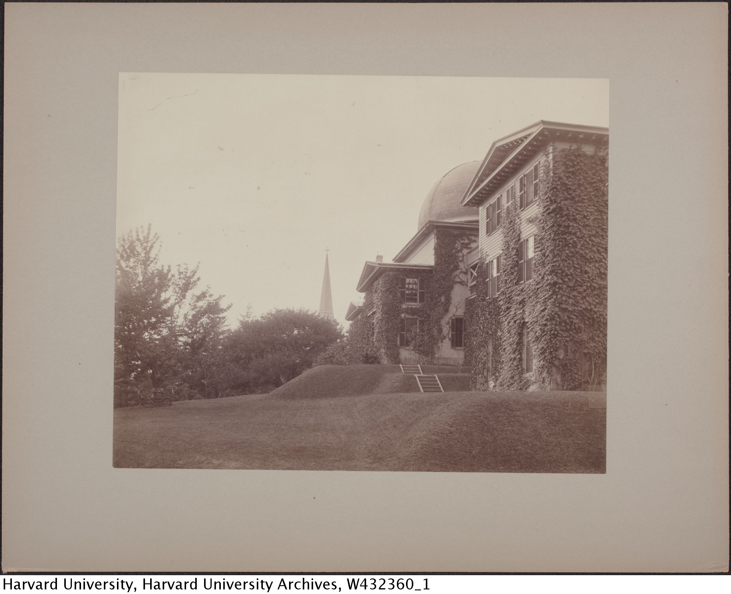
Earliest source: "[Harvard College Observatory, Cambridge, Massachusetts]." Harvard University Archives / UAV 630.271 (E157). Harvard Libraries, olvwork432360
A hard-to-find photo showing this angle of the building, including the director's residence in the foreground.
The key to dating this photo is the wooden balconies, added in 1880ish.harvardreport8081(missing) At the other end of the range, the residence was expanded in 1892 or 1893.
The tree on the left seems to have an odd sculpture or bench in front of it or around it. The vine growth is all new since Roosevelt's 1874 photo, but the tree in that photo has been removed (or the date on that photo is not correct).
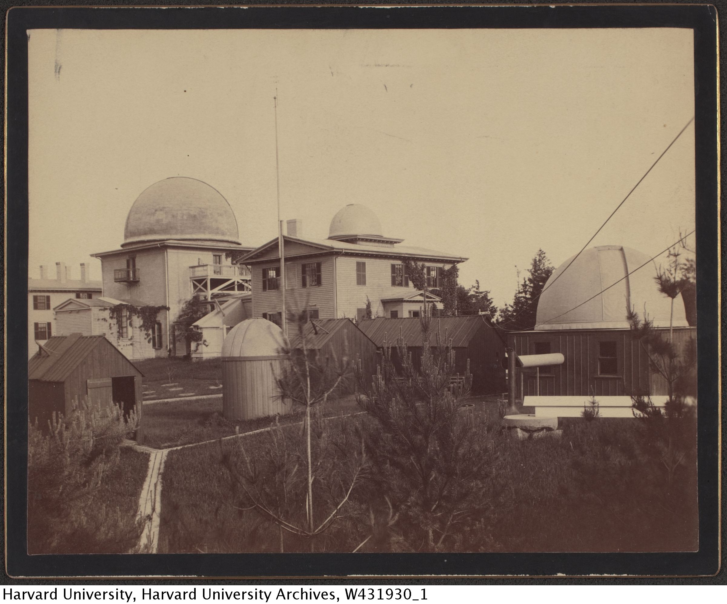
Earliest source: "[Harvard College Observatory, Cambridge, construction, ca. 1892]." Harvard University Archives / UAV 630.271 (278). Harvard Libraries, olvwork431930
Harvard dates this image as 1892, but that's definitely wrong. Instead of three large domes seen in later photos, there's only one. This dates the photo fairly tightly. By late 1886, the first of these domes (this one) was completed to house the 11-inch refractor donated by Mrs. Draper for an astrophotographic survey.annual1886 The next two domes (missing here) were completed sometime during 1877.annual1887 This image is taken from the same angle as many later images, except from a lower position. Perhaps from a window of the house from which later, higher photos were taken from a platform, which didn't exist at thist time.
Note that the two twin wooden sheds are not twins here, one being quite a bit longer than the other. In later photos they are the same size.
Also, the shed for the 8" telescope does not have the sliding roof supports yet. Either this was during construction, or there was a period of time perhaps when the roof sections were simply removed.
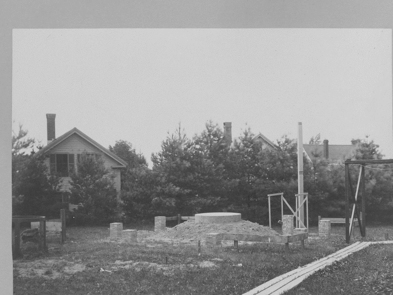
Image Credit: Thomas A. Fine
Construction of the dome to contain the 28-inch reflector donated by Mrs. Draper for the Draper Memorial project.
Eleven photos processed into an animated gif.
Some alternate copies of these images have penciled in dates, and based on this, the construction began before July 12, 1887 (when the platform was completed), and completed after September 1 of the same year (when the building skirt was added but the dome skirt was not in place).
A copy of the sixth image in the sequence has a date written on it, which dates the middle of the construction to July 27, 1887.olvwork432353(missing) The position of the building makes it clear that this is the dome for the 28-inch reflector, which was the second of the three large additional domes that were built.
Use/Copyright: This work is licensed under a Creative Commons Attribution 4.0 International License. 
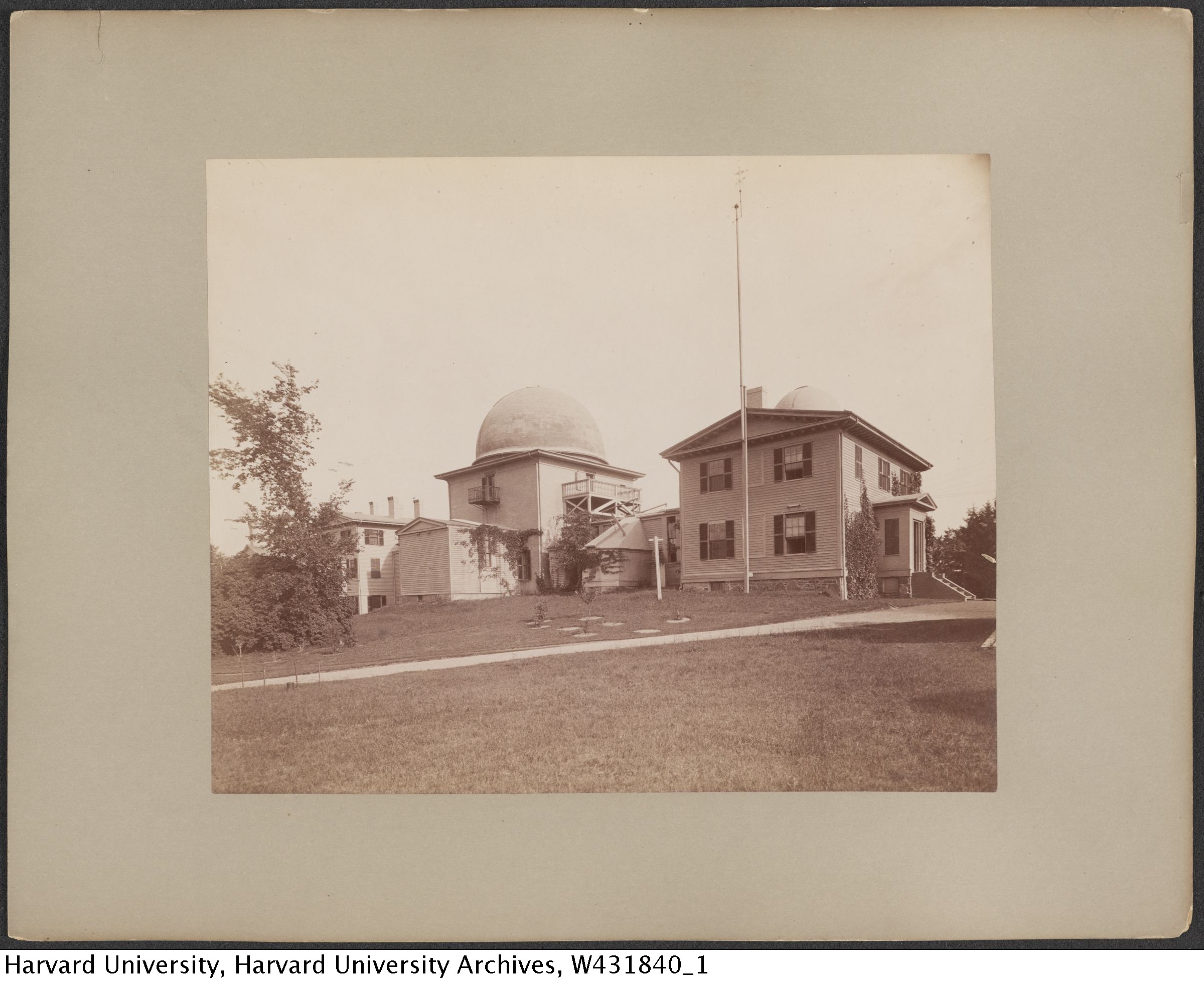
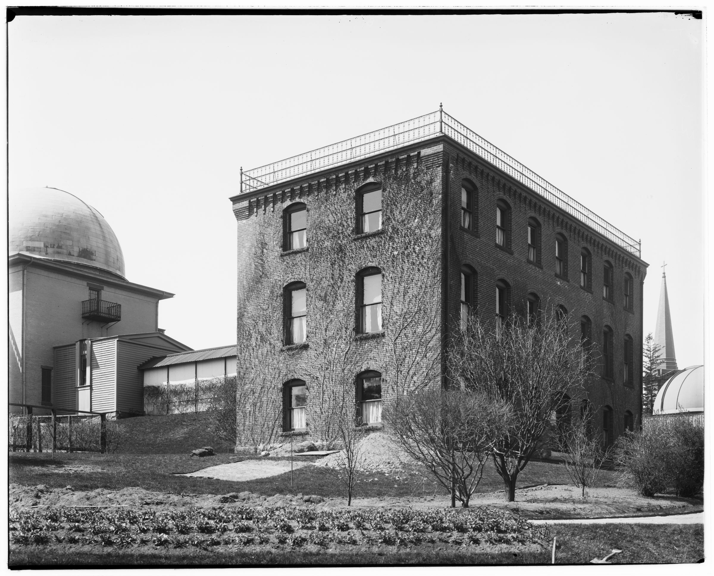
Earliest source: "[Harvard College Observatory buildings in Cambridge]." Harvard University Archives / UAV 630.271 (188). Harvard Libraries, olvwork431840
The Sears Tower and the west wing with the west equatorial dome. Before the brick building. After Sears Tower balconies were replaced with wooden ones in 1880 or 81. Based on the small plants in the foreground and the vine growth on the buildings, I put this just after another photo that also shows these features, as well as a completed dome for the 11-inch refractor, not visible here.
Earliest source: "[Harvard College Observatory, Cambridge, construction, ca. 1892]." Harvard University Archives / UAV 630.271 (279). Harvard Libraries, olvwork431931
Harvard gives this image a date of 1892, which is unlikely. The rightmost dome seems to have construction supplies in front of it, and if that's the case, this dates the image to late 1887 or early 1888, as that is when this third dome was completed for the Boyden Fund.annual1887 I also need to determine when the uncovered 15" reflector was removed and replaced with an odd shed that may be a "meridian photometer" shown in later images. The first two domes were completed in 1886annual1886 and 1887.annual1887 It can't be any later than 1892, because another photo which is prior to the construction of the brick building shows the platform already in place.
This is an unusual angle, reverse of a great many photographs. Just to the left of the dome in the center, is a house which was connected to the observatory—literally. Telegraph lines ran there. This house is the house from which a large number of later pictures were taken. Shown in more detail in a later photo (which also shows the addition of an observing platform that did not exist here).
I have no idea what those two wooden buildings in the foreground housed. But they were removed sometime between the new brick building (1892), and the brick addition (1902). Also, the building on the left was previously longer, and in this photo appears to be very recently shortened.
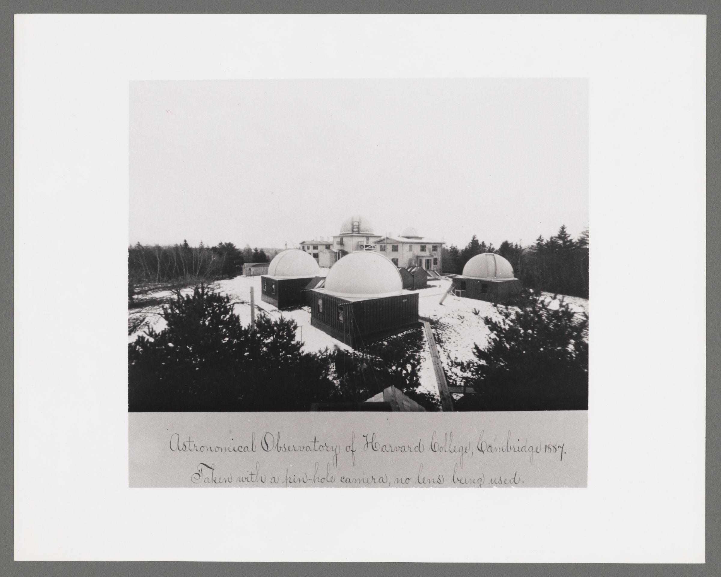
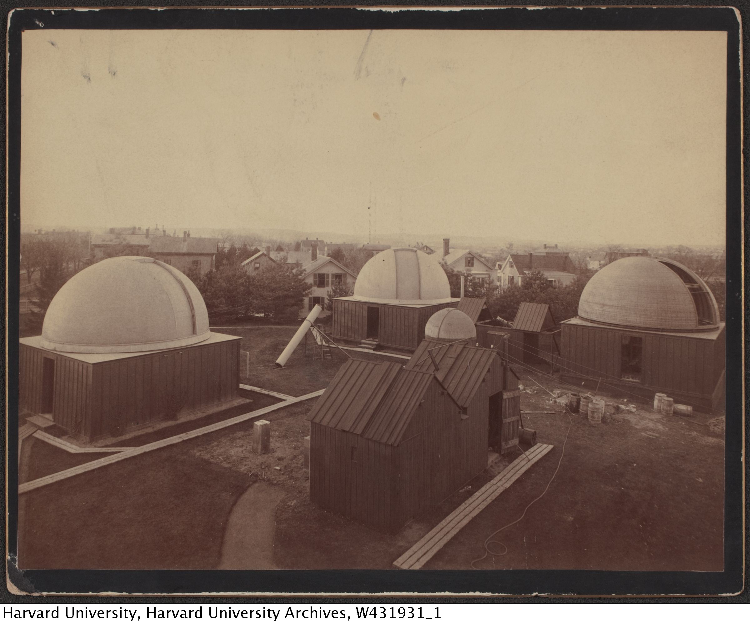
Earliest source: "Astronomical observatory of Harvard College, Cambridge, 1887." Harvard College Observatory Library / 6610-18. Harvard Libraries, olvwork422686
Winter photo via pinhole camera. Only four telegraph lines. The picture is labelled 1887; it's the end rather than the beginning because only one dome existed in the beginning of 1887. I picked December, but it could be any early snowfall in late 1887.
Caption reads:
Astronomical Observatory of Harvard College, Cambridge, 1887.
Taken with a pin-hole camera, no lens being used.
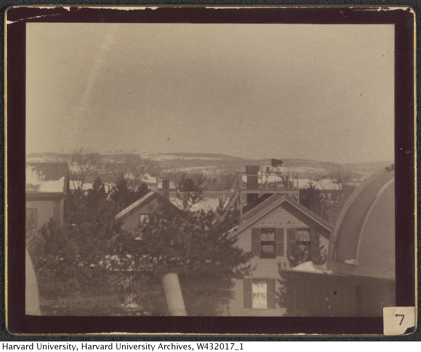
Earliest source: "[View of homes in Cambridge from above with telescope in foreground]." Harvard University Archives / UAV 630.271 (365). Harvard Libraries, olvwork432017
This view was taken from somewhere in the middle of the yard where several instruments were housed. The focus of the picture is the house from which many of these photos were taken. You can see an observation deck in place on the house (not yet installed in the previous image), with a camera on a tripod. You can also see spots where telegraph wires were mounted, although I can't tell how many actual lines are in place here.
Image Credit: L. Grant
Earliest source: Daniel W. Baker. History of the Harvard College Observatory During the Period 1840-1890. 1890.baker90
Not many images from this timeframe, and no others I know of from this particular angle. More tree growth than in the 1850s images.
Preface to this book by Edward C. Pickering, September 13, 1890

Earliest source: Daniel W. Baker. History of the Harvard College Observatory During the Period 1840-1890. 1890.baker90
This is the same angle as many later images, and probably based on a photo.
Building C (the Astrophotographic Building) is notably absent, as are some of the instruments in later photos of the foreground area. There are only four telegraph lines on the front corner of the nearest dome, where later photographs show six.
The image is signed(?) as "Photo Elec Co; Boston".
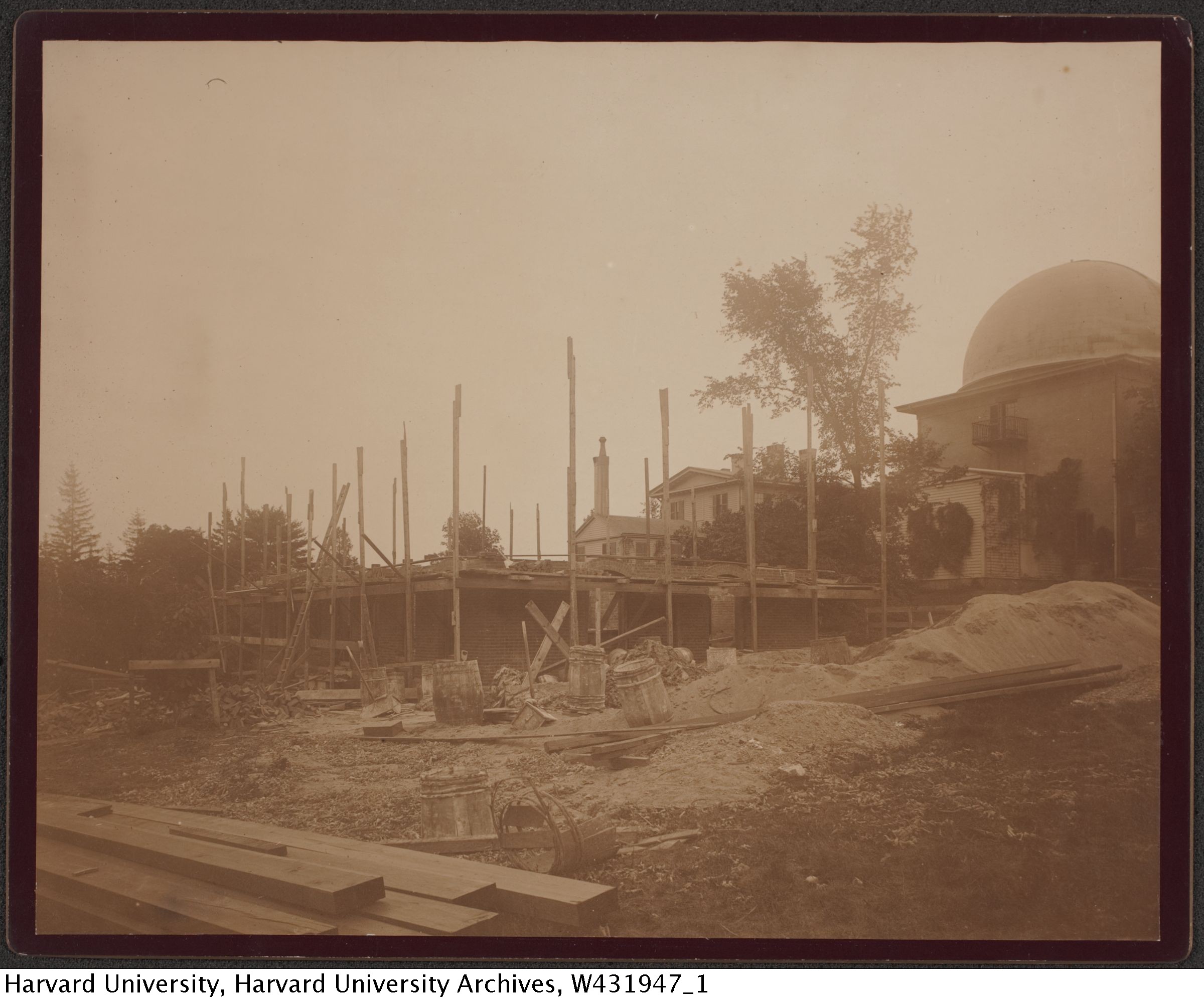
Earliest source: "[Harvard College Observatory, Cambridge, construction, ca. 1892]." Harvard University Archives / UAV 630.271 (295). Harvard Libraries, olvwork431947
[Harvard College Observatory, Cambridge, construction, ca. 1892]
1892
Creator: Harvard College Observatory, Cambridge
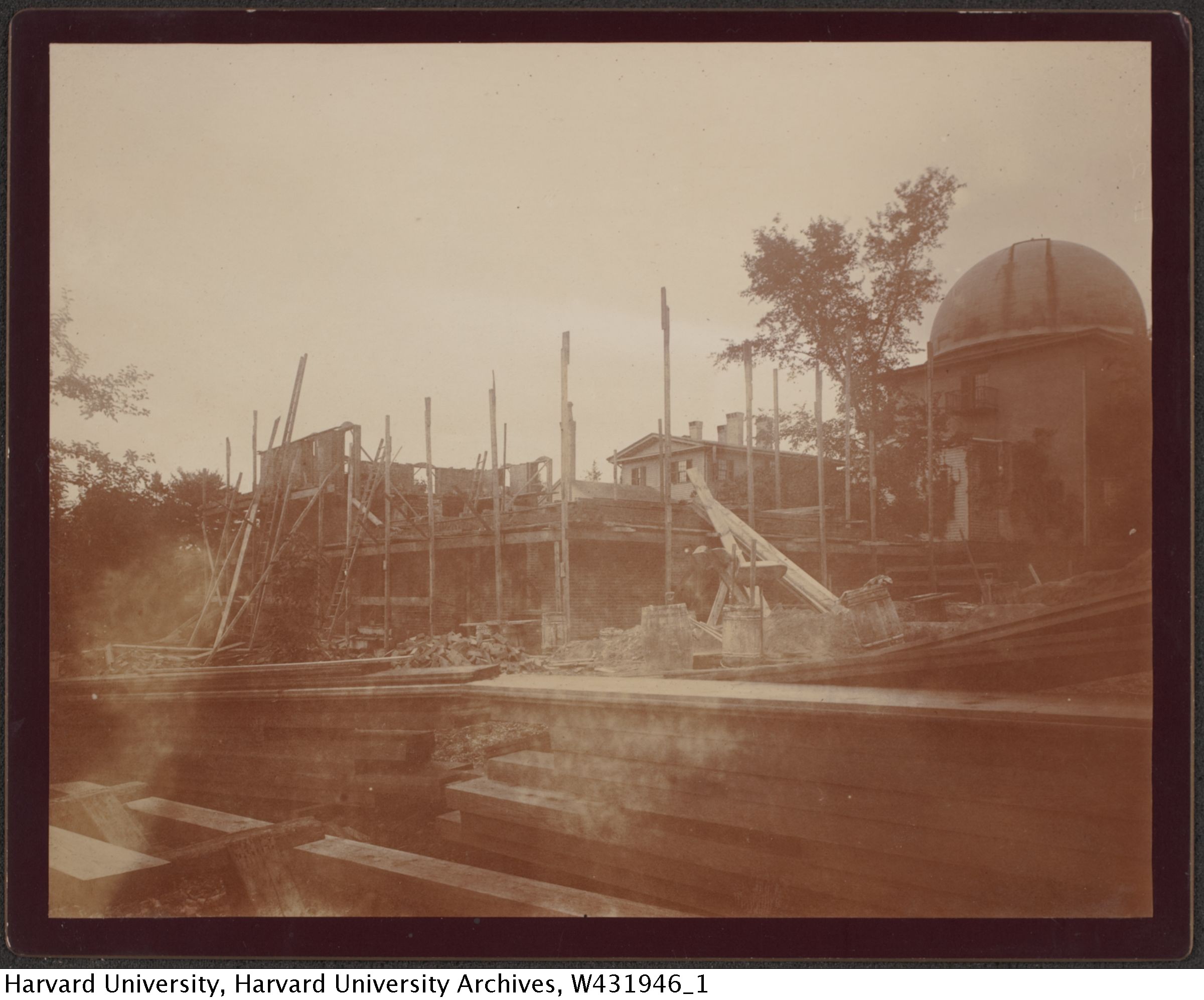
Earliest source: "[Harvard College Observatory, Cambridge, construction, ca. 1892]." Harvard University Archives / UAV 630.271 (294). Harvard Libraries, olvwork431946
[Harvard College Observatory, Cambridge, construction, ca. 1892]
1892
Creator: Harvard College Observatory, Cambridge
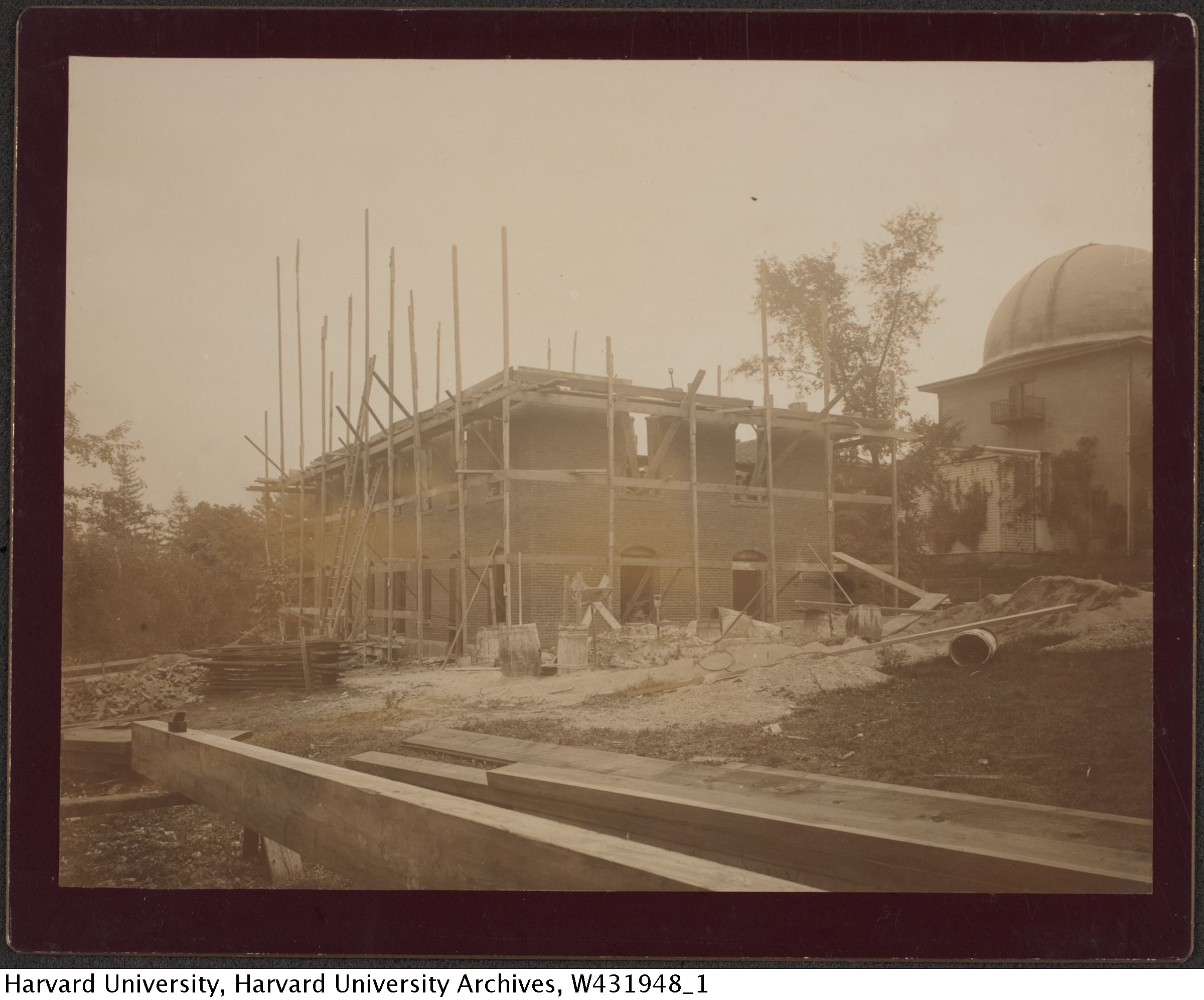
Earliest source: "[Harvard College Observatory, Cambridge, construction, ca. 1892]." Harvard University Archives / UAV 630.271 (296). Harvard Libraries, olvwork431948
[Harvard College Observatory, Cambridge, construction, ca. 1892]
1892
Creator: Harvard College Observatory, Cambridge
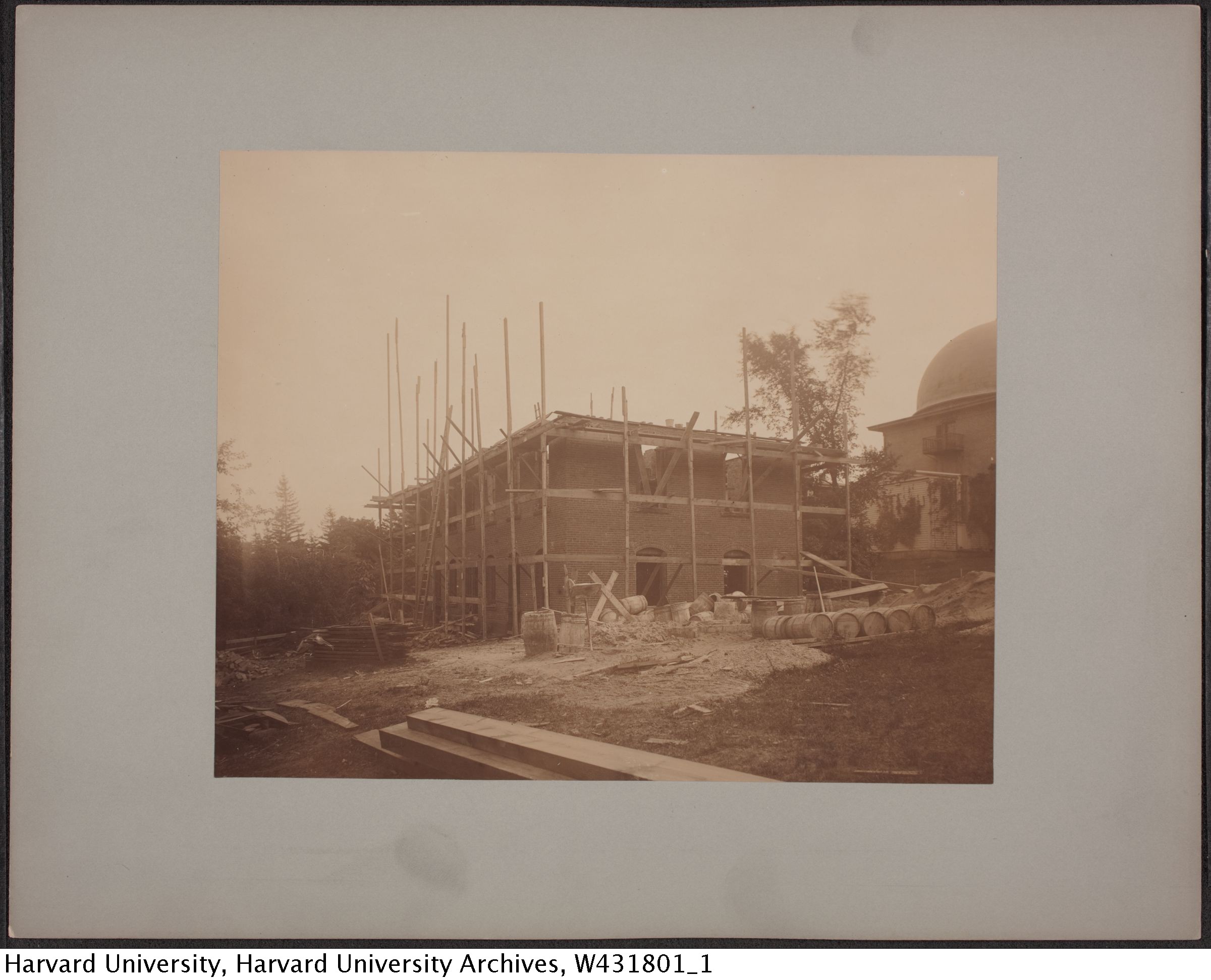
Earliest source: "[Harvard College Observatory building under contruction] 1892." Harvard University Archives / UAV 630.271 (149). Harvard Libraries, olvwork431801
[Harvard College Observatory building under contruction] 1892
1892
Creator: Harvard College Observatory, Cambridge
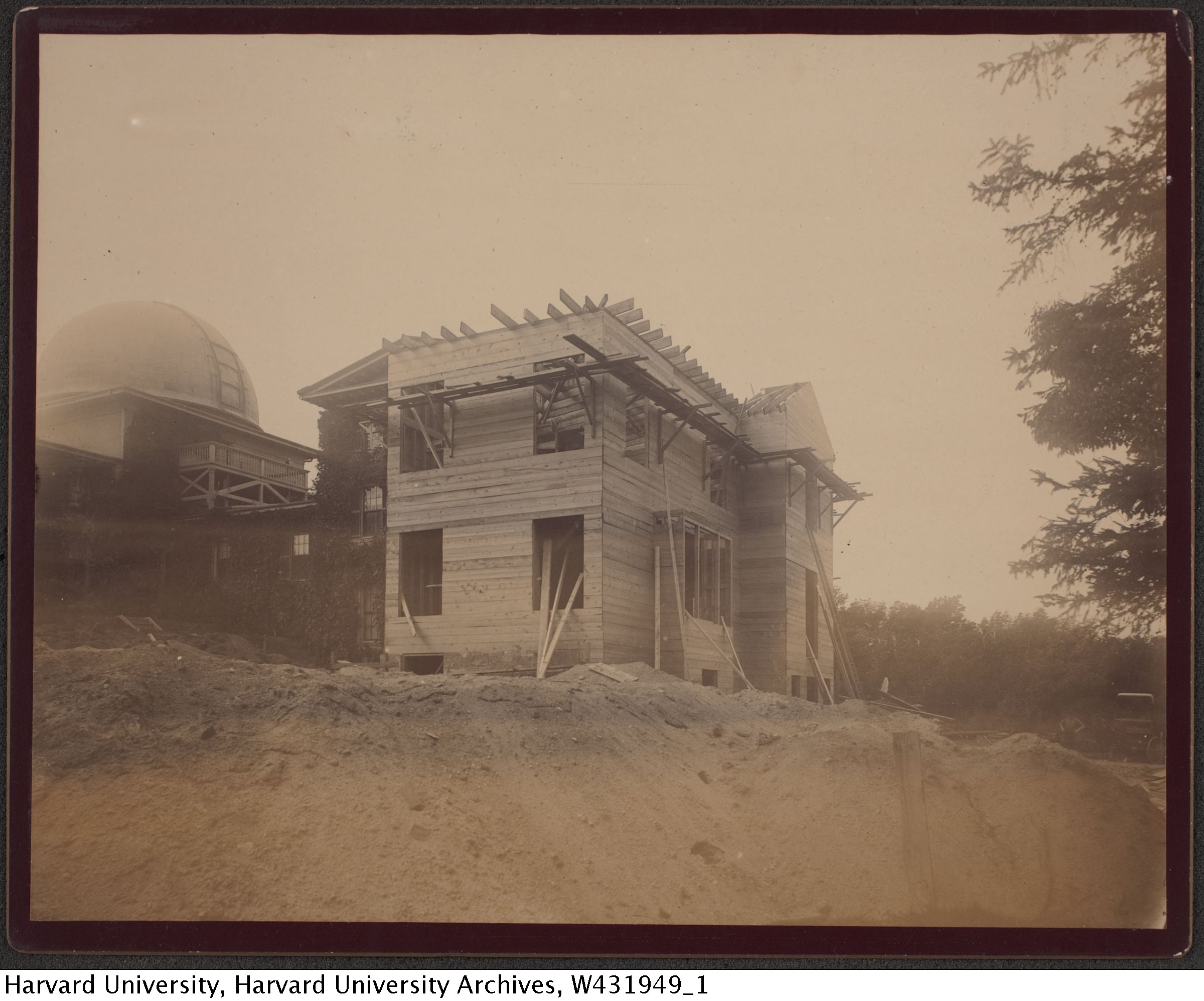
Earliest source: "[Harvard College Observatory, Cambridge, construction, ca. 1892]." Harvard University Archives / UAV 630.271 (297). Harvard Libraries, olvwork431949
Construction of the addition to the Director's Residence (the east wing of the Observatory), completed in 1893.annual1893 The construction began in 1892, but as of October they had only completed basic earth-moving.annual1892
This addition was made under unusual circumstances. Up until then, Director Pickering's salary was reduced, because his occupation of the residence was part of his compensation. Under a new arrangement, Pickering paid for the addition himself, and his salary continued to be reduced. But in return for footing the bill, Harvard allocated his salary reduction to the Observatory rather than the university at large.annual1892 Pickering was both an employee and benefactor of the Observatory.

Earliest source: "[Harvard College Observatory building under contruction] 1892." Harvard University Archives / UAV 630.271 (150). Harvard Libraries, olvwork431802
Construction of the addition to the Director's Residence, 1893.annual1893

Earliest source:
The building farthest to the left is the Astrophotographic Building or Astrophotographic Museum (later called the "brick building", now simply called "Building C"). It was built in 1892, and expanded in 1902. This dates the building in that time range, and the lack of a railing found on the building in later photographs (but still prior to the addition) puts it towards the early end of that range. Based on photos with fresh landscaping which include the railing, I assume this was done almost immediately, which is how I estimated the month (and the fact that there's still hints of snow on the ground).
This photo also lacks the covered/enclosed walkway from the great refractor to the astrophotographic building found in later pictures.
Note in the enlarged image all the telegraph wires. Observatories were in quick contact with each other to confirm observations. Telegraphs were also used for synchronized observing, and Harvard experimented with equipment for recording synchronized clock times via telegraph.
The version of this image stored at Harvard was reversed left-to-right. The copies here have been corrected.
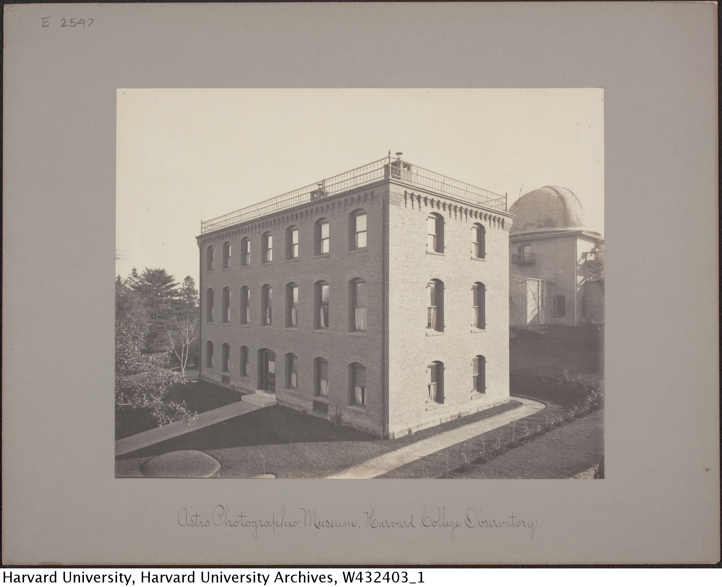
Earliest source: "Astro Photographic Museum. Harvard College Observatory [(i.e. C building)] ." Harvard University Archives / UAV 630.271 (E2547). Harvard Libraries, olvwork432403
Astro Photographic Museum, aka Brick Building, aka Building C (in later years).
This building was completed in 1892. The look of fresh landscaping makes me think this could be early 1893 (but after the transfer of plates in the snowy photo). It has to be after the plate transfer, which shows no railing around the top, while this image has the railing (but no later than 1902 when the addition was built).
This photo looks more professional than many. It was taken from a perfect height to render all the vertical lines perfectly parallel, and the image is so clean that at small scale it looks like an artists' concept drawing.
ca. 1890-ca. 1920
Creator: Harvard College Observatory, Cambridge
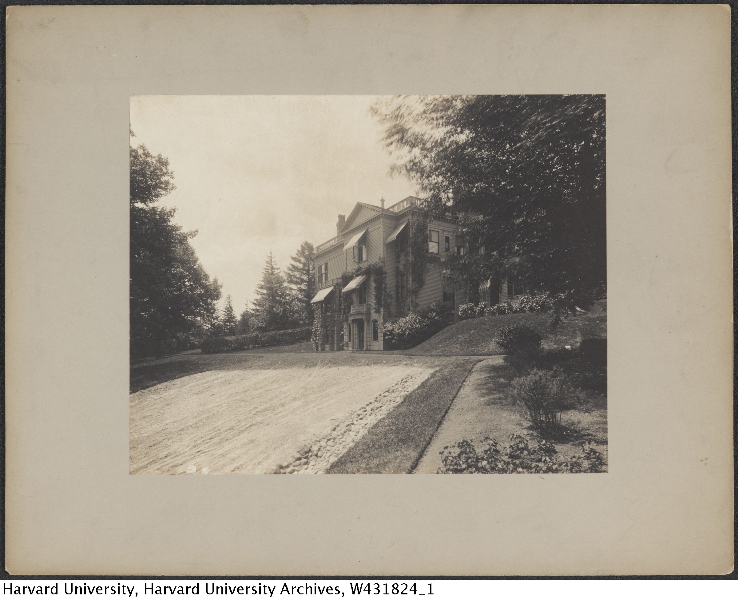
Earliest source: "[Observatory Residence, Cambridge, Massachusetts]." Harvard University Archives / UAV 630.271 (172). Harvard Libraries, olvwork431824
This is the director's residence after the 1893 addition, and this view is entirely of the addition. Several group photos were taken here, including the "paper doll" photo. (Or at least the 1918 AAS group photo, not yet added here.) Based on the vines, it's a least a couple of years after the addition was completed.
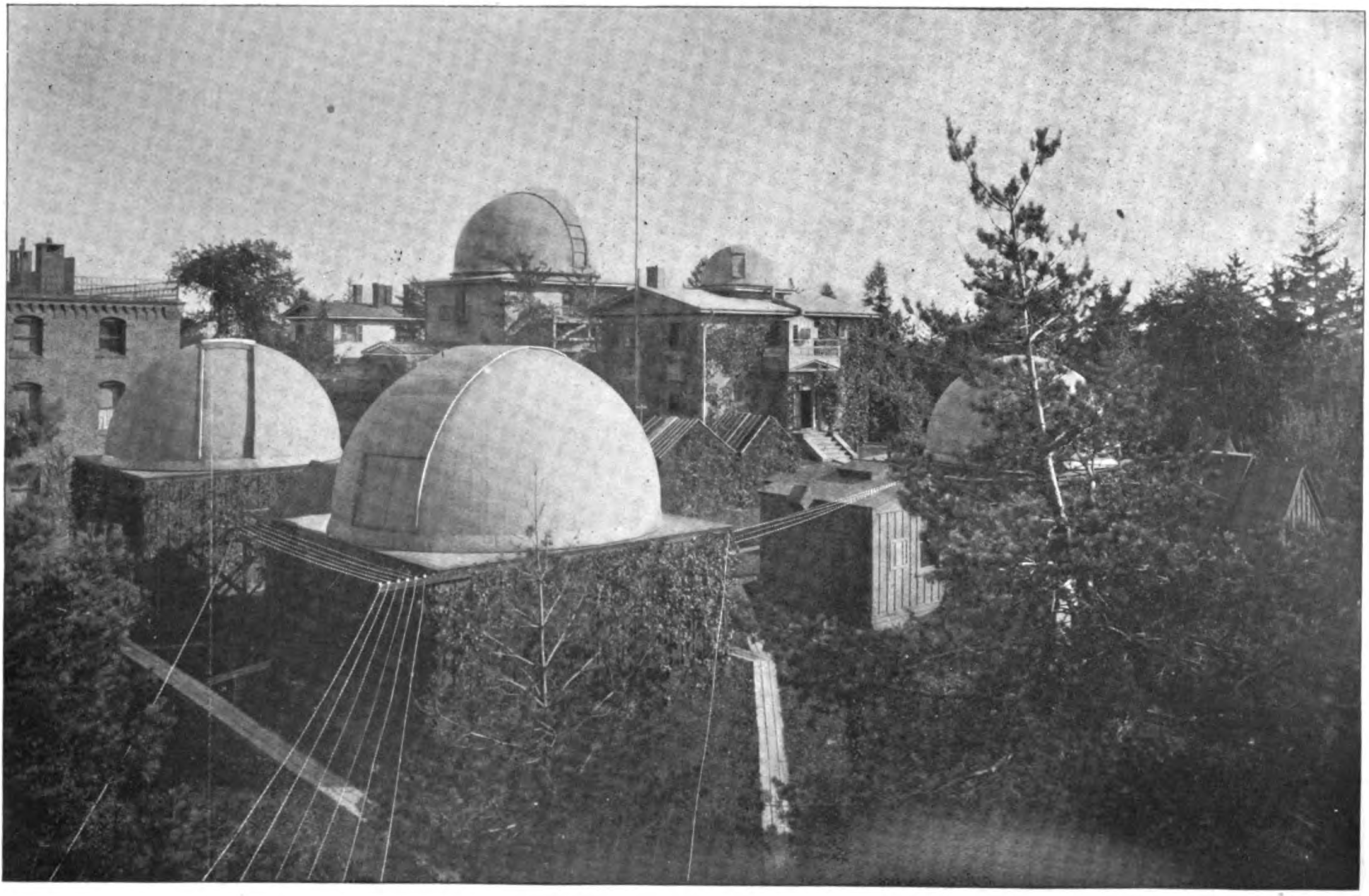
This image dated to before November of 1898. The railing on the astrophotographic building has been added. Also a pipe of some sort appears on the small dome of the original building. But the two twin buildings whose roofs form an "M" is still there close to the original building.

The twin "M" buildings near the original building have been removed.
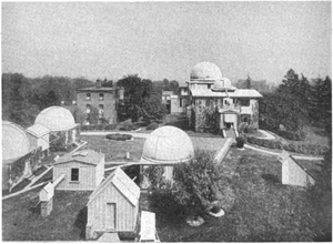
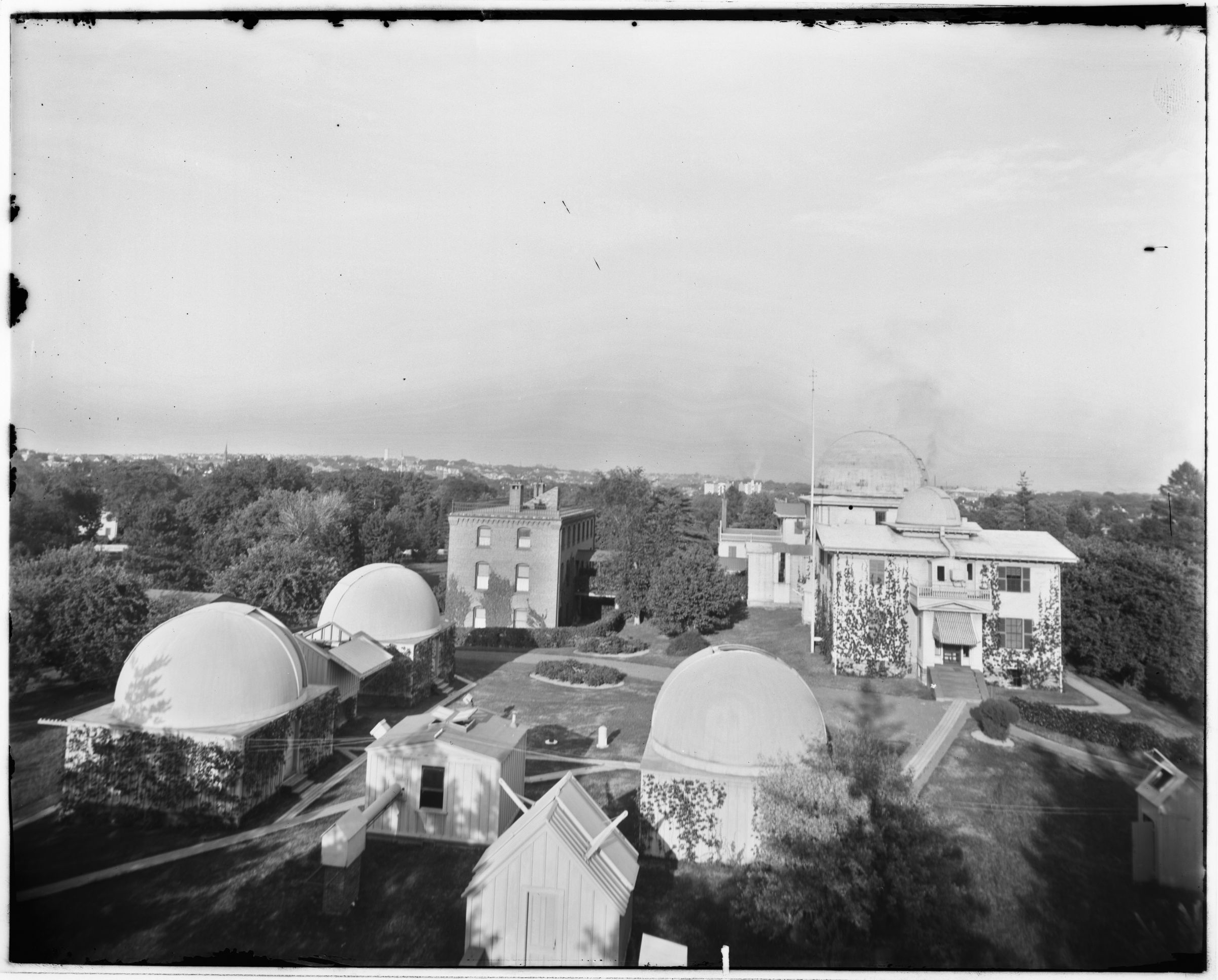
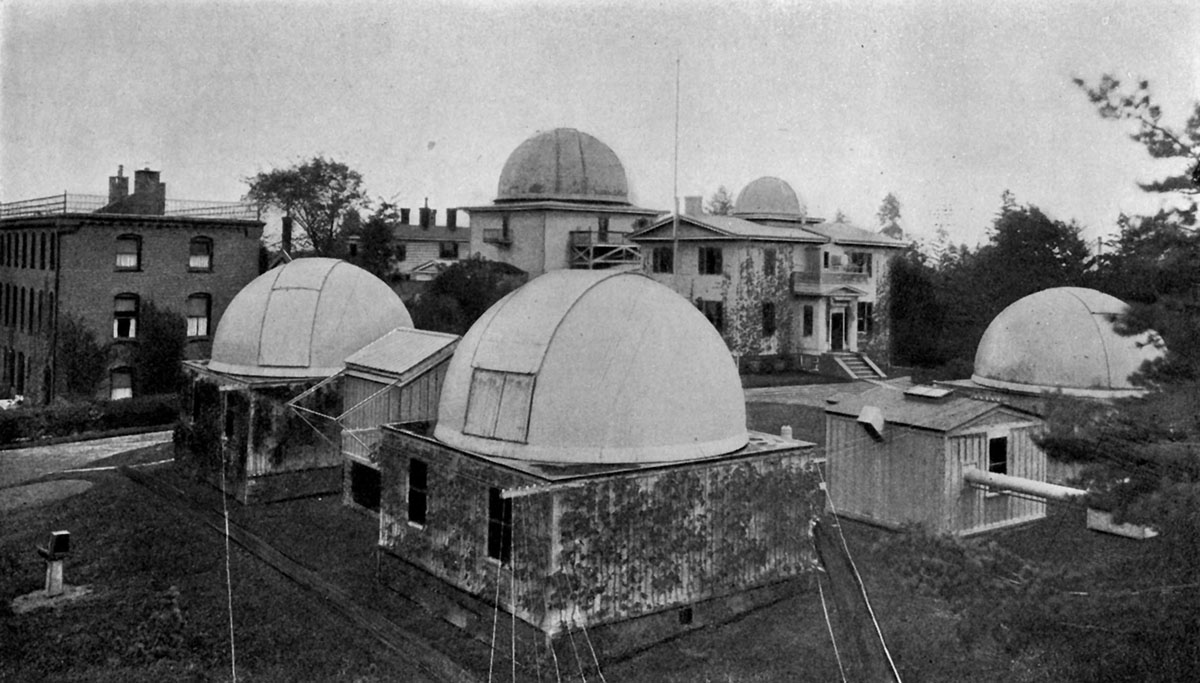
Earliest source: Edward C. Pickering. "The Astronomical Observatory." Harvard Alumni Bulletin vol. 17 no. 23. Harvard Bulletin, Inc. Boston, Mass., 10 March 1915.alumni1915
This article was published in 1915, but is clearly an older photo of the observatory. It is almost identical to an image above, except that image shows three intsruments open which are all closed here. Other than that they appear identical. (exact same angle, same instruments, awning on the original building, pipe on the roof of original building, domes facing the same directions, even the slightly open curtains in builing C appear the same).
This image is also found in "The Henry Draper Memorial" by Annie J. Cannon from The Journal of the Royal Astronomical Society of Canada, v. 9. 1915.
The image found there identifies many of the instruments:
Original from Harvard is mirrored, this image has been flipped to fix it.
If you look above the leftmost dome, you'll see a small rooftop. I think this is the Bruce doublet building. It was housed at Harvard in 1893-95 before being moved to peru, and photographs show that it was in a small brick building with an angled roof. I haven't found it in any other wider photos of the Observatory grounds, so I can only assume this is it.
Earliest source: George C. Comstock. A Textbook of Astronomy. 1901?.comstocktextbook
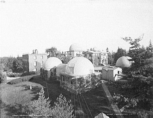
A slightly wider angle than some of the other images
"The Harvard Astrophotographic Museum". Also known to me as my office building. The building was expanded in 1902, as documented in photos that will be added below. This photo is part of that series, and appears to be a different print of the first image of the series used to make the animation below. The building was mostly completed in 1892.annual1892 crimson18921019(missing) It was completed in 1893 and the plates were transferred.annual1893
Apparently this plate transfer involved loading the plates (which are heavy, fragile glass) into crates, 100 plates at a time, and letting them run downhill on a rope and pulley system from a window in the west wing of the old observatory and safely into the new building.annual1893
Image Credit: Thomas A. Fine
Earliest source:
An animated gif built from a selection of related images.
Use/Copyright: This work is licensed under a Creative Commons Attribution 4.0 International License.
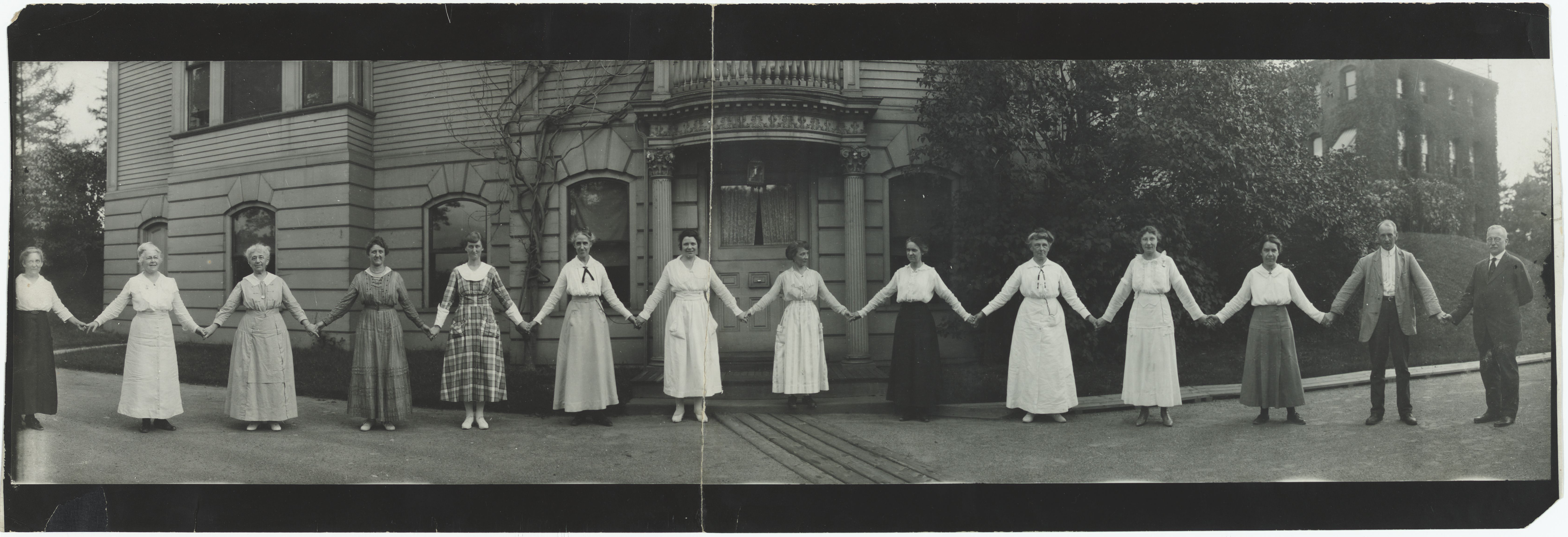
Earliest source: "[Observatory Staff in "paper doll" pose, (in line holding hands) panoramic photograph ca. 1918]." Harvard University Archives / UAV 630.271 (391). Harvard Libraries, olvwork432043
From left to right (primary identifications come from Harvard, who says the names were listed on the back):
I believe the correct names for two of these are "Mary H. Vann" and "Dorothy Block".jaavsoharwood Also, I think this is Mabel, not Edith Gill (or the few other labelled photos I've seen so far similarly mislabel the presumed sisters).
For the longest time I didn't know where pictures like this one were taken. This is an addition to the director's residence added in about 1893 that maybe doubled the size of the residence. The building is not curved, and the brick building to the right is the end of the astrophotographic addition, lying in the same plane. The wide angle just makes it look like a 90 degree bend.
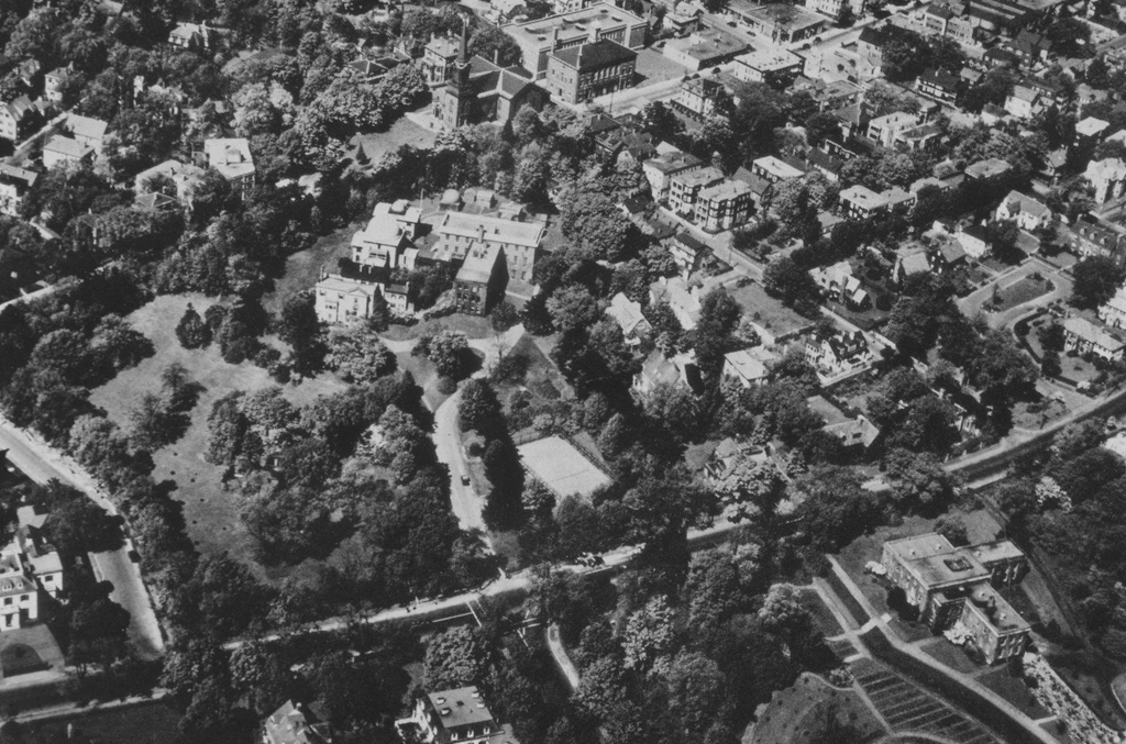
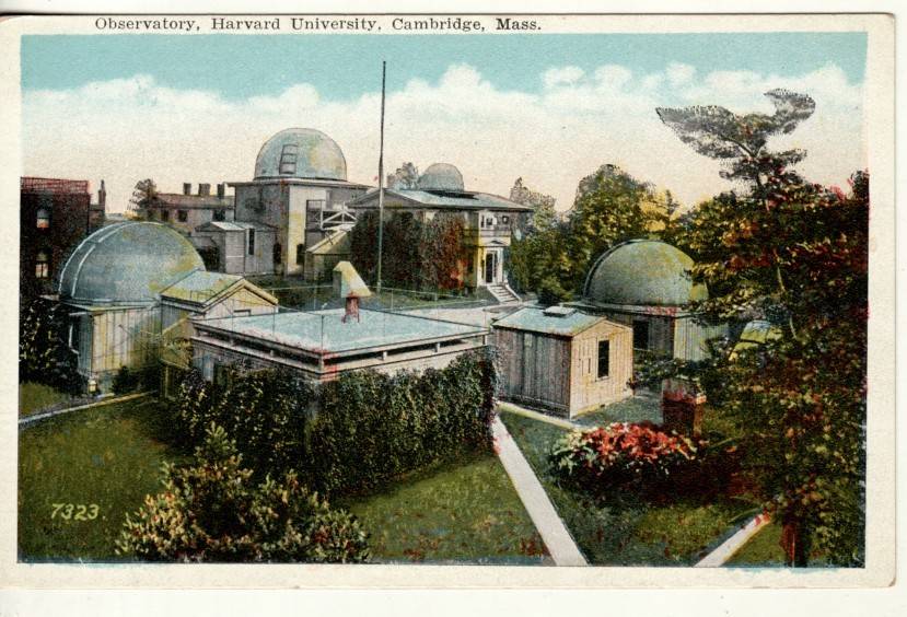
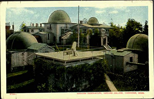
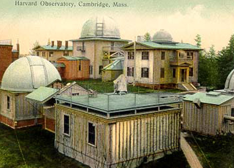
An Aerial view of the Observatory, unknown date. The newest plate stacks addition from 1931 is visible, but the 1954 replacement of the original frame buildings surrounding the Sears Tower has not yet happened. The 28" reflector dome (northwest corner) is missing - the structure still exists but the top is now a platform. The 8" refractor shed and the 12" refractor dome are still in place.
The building in the lower right is Kittridge Hall, home of the Harvard Press.